You are here: Home > Network List > TA - USArray Transportable Network (new EarthScope stations) Stations List
> Station D51A Lot 18 Range III Mazenod Township, QC, CAN > Earthquake Result Viewer
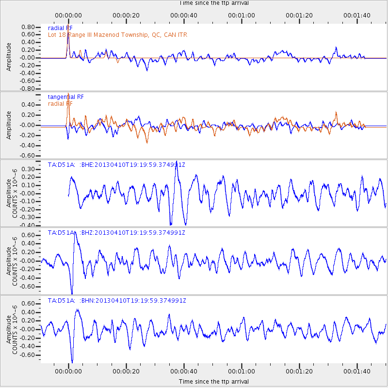
D51A Lot 18 Range III Mazenod Township, QC, CAN - Earthquake Result Viewer
*The percent match for this event was below the threshold and hence no stack was calculated.
| Earthquake location: |
Honduras |
| Earthquake latitude/longitude: |
15.5/-87.2 |
| Earthquake time(UTC): |
2013/04/10 (100) 19:14:01 GMT |
| Earthquake Depth: |
3.5 km |
| Earthquake Magnitude: |
5.5 MW |
| Earthquake Catalog/Contributor: |
NEIC PDE/NEIC PDE-W |
|
| Network: |
TA USArray Transportable Network (new EarthScope stations) |
| Station: |
D51A Lot 18 Range III Mazenod Township, QC, CAN |
| Lat/Lon: |
47.09 N/79.37 W |
| Elevation: |
282 m |
|
| Distance: |
32.1 deg |
| Az: |
10.021 deg |
| Baz: |
194.211 deg |
| Ray Param: |
$rayparam |
*The percent match for this event was below the threshold and hence was not used in the summary stack. |
|
| Radial Match: |
49.15197 % |
| Radial Bump: |
400 |
| Transverse Match: |
46.72893 % |
| Transverse Bump: |
400 |
| SOD ConfigId: |
512894 |
| Insert Time: |
2013-09-13 04:05:54.905 +0000 |
| GWidth: |
2.5 |
| Max Bumps: |
400 |
| Tol: |
0.001 |
|
Signal To Noise
| Channel | StoN | STA | LTA |
| TA:D51A: :BHZ:20130410T19:19:59.374991Z | 2.6509514 | 4.182143E-7 | 1.5776008E-7 |
| TA:D51A: :BHN:20130410T19:19:59.374991Z | 3.0810592 | 3.7602916E-7 | 1.2204542E-7 |
| TA:D51A: :BHE:20130410T19:19:59.374991Z | 1.0736786 | 9.1905186E-8 | 8.5598415E-8 |
| Arrivals |
| Ps | |
| PpPs | |
| PsPs/PpSs | |


