You are here: Home > Network List > TA - USArray Transportable Network (new EarthScope stations) Stations List
> Station E54A Lac Daplat, Pontiac, MRC, QC, CAN > Earthquake Result Viewer
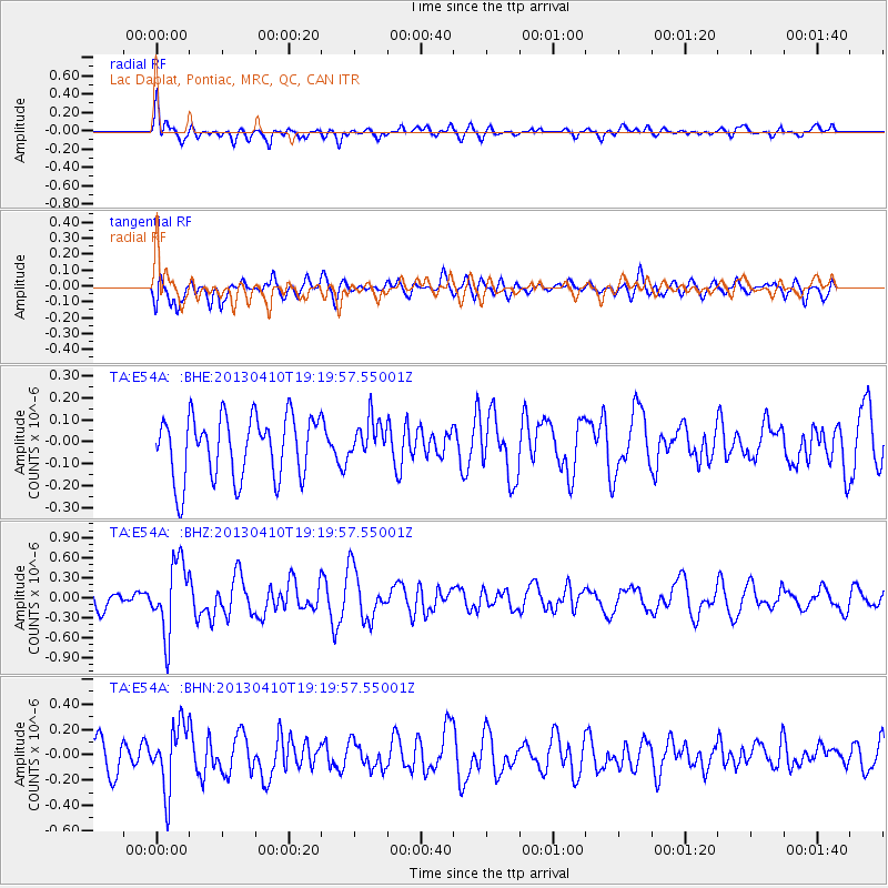
E54A Lac Daplat, Pontiac, MRC, QC, CAN - Earthquake Result Viewer
*The percent match for this event was below the threshold and hence no stack was calculated.
| Earthquake location: |
Honduras |
| Earthquake latitude/longitude: |
15.5/-87.2 |
| Earthquake time(UTC): |
2013/04/10 (100) 19:14:01 GMT |
| Earthquake Depth: |
3.5 km |
| Earthquake Magnitude: |
5.5 MW |
| Earthquake Catalog/Contributor: |
NEIC PDE/NEIC PDE-W |
|
| Network: |
TA USArray Transportable Network (new EarthScope stations) |
| Station: |
E54A Lac Daplat, Pontiac, MRC, QC, CAN |
| Lat/Lon: |
46.43 N/77.19 W |
| Elevation: |
277 m |
|
| Distance: |
31.9 deg |
| Az: |
13.089 deg |
| Baz: |
198.4 deg |
| Ray Param: |
$rayparam |
*The percent match for this event was below the threshold and hence was not used in the summary stack. |
|
| Radial Match: |
68.87556 % |
| Radial Bump: |
400 |
| Transverse Match: |
54.724392 % |
| Transverse Bump: |
400 |
| SOD ConfigId: |
512894 |
| Insert Time: |
2013-09-13 04:06:48.791 +0000 |
| GWidth: |
2.5 |
| Max Bumps: |
400 |
| Tol: |
0.001 |
|
Signal To Noise
| Channel | StoN | STA | LTA |
| TA:E54A: :BHZ:20130410T19:19:57.55001Z | 2.4698565 | 5.3027986E-7 | 2.1470068E-7 |
| TA:E54A: :BHN:20130410T19:19:57.55001Z | 1.8203348 | 2.5757237E-7 | 1.4149724E-7 |
| TA:E54A: :BHE:20130410T19:19:57.55001Z | 0.6185342 | 8.8165145E-8 | 1.4253884E-7 |
| Arrivals |
| Ps | |
| PpPs | |
| PsPs/PpSs | |


