You are here: Home > Network List > TA - USArray Transportable Network (new EarthScope stations) Stations List
> Station O03E Paynes Creek, CA, USA > Earthquake Result Viewer
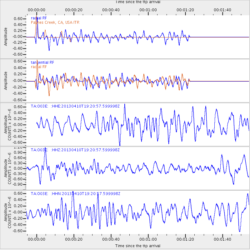
O03E Paynes Creek, CA, USA - Earthquake Result Viewer
*The percent match for this event was below the threshold and hence no stack was calculated.
| Earthquake location: |
Honduras |
| Earthquake latitude/longitude: |
15.5/-87.2 |
| Earthquake time(UTC): |
2013/04/10 (100) 19:14:01 GMT |
| Earthquake Depth: |
3.5 km |
| Earthquake Magnitude: |
5.5 MW |
| Earthquake Catalog/Contributor: |
NEIC PDE/NEIC PDE-W |
|
| Network: |
TA USArray Transportable Network (new EarthScope stations) |
| Station: |
O03E Paynes Creek, CA, USA |
| Lat/Lon: |
40.29 N/121.80 W |
| Elevation: |
967 m |
|
| Distance: |
38.9 deg |
| Az: |
316.217 deg |
| Baz: |
119.299 deg |
| Ray Param: |
$rayparam |
*The percent match for this event was below the threshold and hence was not used in the summary stack. |
|
| Radial Match: |
58.077488 % |
| Radial Bump: |
400 |
| Transverse Match: |
49.31544 % |
| Transverse Bump: |
395 |
| SOD ConfigId: |
512894 |
| Insert Time: |
2013-09-13 04:09:13.260 +0000 |
| GWidth: |
2.5 |
| Max Bumps: |
400 |
| Tol: |
0.001 |
|
Signal To Noise
| Channel | StoN | STA | LTA |
| TA:O03E: :HHZ:20130410T19:20:57.599998Z | 3.1353815 | 4.83723E-7 | 1.5427884E-7 |
| TA:O03E: :HHN:20130410T19:20:57.599998Z | 0.67658633 | 8.2913765E-8 | 1.225472E-7 |
| TA:O03E: :HHE:20130410T19:20:57.599998Z | 1.2762295 | 2.1947281E-7 | 1.719697E-7 |
| Arrivals |
| Ps | |
| PpPs | |
| PsPs/PpSs | |


