You are here: Home > Network List > US - United States National Seismic Network Stations List
> Station BOZ Bozeman, Montana, USA > Earthquake Result Viewer
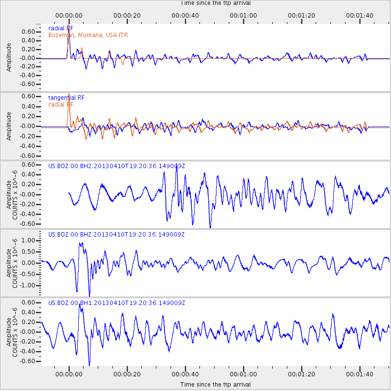
BOZ Bozeman, Montana, USA - Earthquake Result Viewer
*The percent match for this event was below the threshold and hence no stack was calculated.
| Earthquake location: |
Honduras |
| Earthquake latitude/longitude: |
15.5/-87.2 |
| Earthquake time(UTC): |
2013/04/10 (100) 19:14:01 GMT |
| Earthquake Depth: |
3.5 km |
| Earthquake Magnitude: |
5.5 MW |
| Earthquake Catalog/Contributor: |
NEIC PDE/NEIC PDE-W |
|
| Network: |
US United States National Seismic Network |
| Station: |
BOZ Bozeman, Montana, USA |
| Lat/Lon: |
45.65 N/111.63 W |
| Elevation: |
1589 m |
|
| Distance: |
36.4 deg |
| Az: |
330.675 deg |
| Baz: |
137.697 deg |
| Ray Param: |
$rayparam |
*The percent match for this event was below the threshold and hence was not used in the summary stack. |
|
| Radial Match: |
72.35805 % |
| Radial Bump: |
400 |
| Transverse Match: |
67.156555 % |
| Transverse Bump: |
400 |
| SOD ConfigId: |
512894 |
| Insert Time: |
2013-09-13 04:09:42.016 +0000 |
| GWidth: |
2.5 |
| Max Bumps: |
400 |
| Tol: |
0.001 |
|
Signal To Noise
| Channel | StoN | STA | LTA |
| US:BOZ:00:BHZ:20130410T19:20:36.149009Z | 3.7794495 | 5.881241E-7 | 1.5561106E-7 |
| US:BOZ:00:BH1:20130410T19:20:36.149009Z | 2.4295776 | 2.998192E-7 | 1.2340384E-7 |
| US:BOZ:00:BH2:20130410T19:20:36.149009Z | 2.0550625 | 2.6589623E-7 | 1.2938595E-7 |
| Arrivals |
| Ps | |
| PpPs | |
| PsPs/PpSs | |


