You are here: Home > Network List > US - United States National Seismic Network Stations List
> Station DGMT Dagmar, Montana, USA > Earthquake Result Viewer
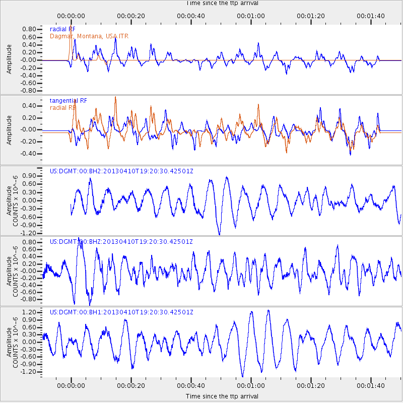
DGMT Dagmar, Montana, USA - Earthquake Result Viewer
*The percent match for this event was below the threshold and hence no stack was calculated.
| Earthquake location: |
Honduras |
| Earthquake latitude/longitude: |
15.5/-87.2 |
| Earthquake time(UTC): |
2013/04/10 (100) 19:14:01 GMT |
| Earthquake Depth: |
3.5 km |
| Earthquake Magnitude: |
5.5 MW |
| Earthquake Catalog/Contributor: |
NEIC PDE/NEIC PDE-W |
|
| Network: |
US United States National Seismic Network |
| Station: |
DGMT Dagmar, Montana, USA |
| Lat/Lon: |
48.47 N/104.20 W |
| Elevation: |
0.0 m |
|
| Distance: |
35.7 deg |
| Az: |
340.491 deg |
| Baz: |
151.07 deg |
| Ray Param: |
$rayparam |
*The percent match for this event was below the threshold and hence was not used in the summary stack. |
|
| Radial Match: |
80.16964 % |
| Radial Bump: |
374 |
| Transverse Match: |
56.21551 % |
| Transverse Bump: |
329 |
| SOD ConfigId: |
512894 |
| Insert Time: |
2013-09-13 04:09:53.613 +0000 |
| GWidth: |
2.5 |
| Max Bumps: |
400 |
| Tol: |
0.001 |
|
Signal To Noise
| Channel | StoN | STA | LTA |
| US:DGMT:00:BHZ:20130410T19:20:30.42501Z | 3.927651 | 5.7492883E-7 | 1.4637982E-7 |
| US:DGMT:00:BH1:20130410T19:20:30.42501Z | 0.9410907 | 2.6576868E-7 | 2.8240495E-7 |
| US:DGMT:00:BH2:20130410T19:20:30.42501Z | 1.2419006 | 3.680824E-7 | 2.9638636E-7 |
| Arrivals |
| Ps | |
| PpPs | |
| PsPs/PpSs | |


