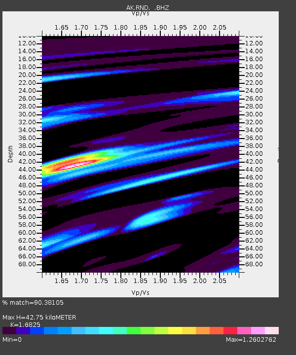
RND Reindeer - Earthquake Result Viewer

Earthquake location: Philippine Islands Region
Earthquake latitude/longitude: 20.7/122.1
Earthquake time(UTC): 2013/04/10 (100) 20:20:26 GMT
Earthquake Depth: 12 km
Earthquake Magnitude: 5.8 MW, 5.7 MS, 5.9 MW, 6.0 MB
Earthquake Catalog/Contributor: NEIC PDE/NEIC PDE-W
Network: AK Alaska Regional Network
Station: RND Reindeer
Lat/Lon: 63.41 N/148.86 W
Elevation: 978 m
Distance: 71.3 deg
Az: 28.369 deg
Baz: 278.799 deg
Ray Param: 0.05442891
Estimated Moho Depth: 42.75 km
Estimated Crust Vp/Vs: 1.68
Assumed Crust Vp: 6.566 km/s
Estimated Crust Vs: 3.903 km/s
Estimated Crust Poisson's Ratio: 0.23
Radial Match: 90.38105 %
Radial Bump: 361
Transverse Match: 83.82531 %
Transverse Bump: 400
SOD ConfigId: 512894
Insert Time: 2013-09-13 04:18:25.329 +0000
GWidth: 2.5
Max Bumps: 400
Tol: 0.001

Signal To Noise

ChannelStoNSTALTA
AK:RND: :BHZ:20130410T20:31:14.787976Z16.8432582.4897413E-61.4781827E-7
AK:RND: :BHN:20130410T20:31:14.787976Z3.1217444.7198674E-71.5119329E-7
AK:RND: :BHE:20130410T20:31:14.787976Z6.16753777.9489797E-71.2888417E-7
Arrivals
Ps4.6 SECOND
PpPs17 SECOND
PsPs/PpSs21 SECOND