You are here: Home > Network List > AK - Alaska Regional Network Stations List
> Station WAT4 Susitna Watana 4, AK, USA > Earthquake Result Viewer
WAT4 Susitna Watana 4, AK, USA - Earthquake Result Viewer
| Earthquake location: |
Philippine Islands Region |
| Earthquake latitude/longitude: |
20.7/122.1 |
| Earthquake time(UTC): |
2013/04/10 (100) 20:20:26 GMT |
| Earthquake Depth: |
12 km |
| Earthquake Magnitude: |
5.8 MW, 5.7 MS, 5.9 MW, 6.0 MB |
| Earthquake Catalog/Contributor: |
NEIC PDE/NEIC PDE-W |
|
| Network: |
AK Alaska Regional Network |
| Station: |
WAT4 Susitna Watana 4, AK, USA |
| Lat/Lon: |
62.83 N/147.94 W |
| Elevation: |
1191 m |
|
| Distance: |
71.8 deg |
| Az: |
28.894 deg |
| Baz: |
279.781 deg |
| Ray Param: |
0.054092567 |
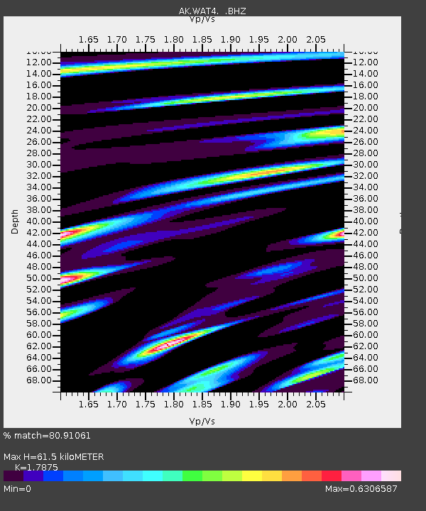
| Estimated Moho Depth: |
61.5 km |
| Estimated Crust Vp/Vs: |
1.79 |
| Assumed Crust Vp: |
6.566 km/s |
| Estimated Crust Vs: |
3.673 km/s |
| Estimated Crust Poisson's Ratio: |
0.27 |
|
| Radial Match: |
80.91061 % |
| Radial Bump: |
386 |
| Transverse Match: |
72.9227 % |
| Transverse Bump: |
400 |
| SOD ConfigId: |
512894 |
| Insert Time: |
2013-09-13 04:19:04.622 +0000 |
| GWidth: |
2.5 |
| Max Bumps: |
400 |
| Tol: |
0.001 |
|

Signal To Noise
| Channel | StoN | STA | LTA |
| AK:WAT4: :BHZ:20130410T20:31:17.807996Z | 9.144405 | 1.579472E-6 | 1.7272552E-7 |
| AK:WAT4: :BHN:20130410T20:31:17.807996Z | 1.345569 | 2.5800426E-7 | 1.9174361E-7 |
| AK:WAT4: :BHE:20130410T20:31:17.807996Z | 6.243136 | 9.256414E-7 | 1.4826546E-7 |
| Arrivals |
| Ps | 7.7 SECOND |
| PpPs | 25 SECOND |
| PsPs/PpSs | 33 SECOND |


