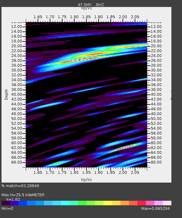
SMY Shemya, Alaska - Earthquake Result Viewer

Earthquake location: Philippine Islands Region
Earthquake latitude/longitude: 20.7/122.1
Earthquake time(UTC): 2013/04/10 (100) 20:20:26 GMT
Earthquake Depth: 12 km
Earthquake Magnitude: 5.8 MW, 5.7 MS, 5.9 MW, 6.0 MB
Earthquake Catalog/Contributor: NEIC PDE/NEIC PDE-W
Network: AT Alaska Tsunami Warning Seismic System
Station: SMY Shemya, Alaska
Lat/Lon: 52.73 N/174.10 E
Elevation: 58 m
Distance: 51.0 deg
Az: 38.099 deg
Baz: 251.763 deg
Ray Param: 0.06768826
Estimated Moho Depth: 25.5 km
Estimated Crust Vp/Vs: 1.82
Assumed Crust Vp: 3.999 km/s
Estimated Crust Vs: 2.197 km/s
Estimated Crust Poisson's Ratio: 0.28
Radial Match: 83.28948 %
Radial Bump: 400
Transverse Match: 74.88735 %
Transverse Bump: 400
SOD ConfigId: 512894
Insert Time: 2013-09-13 04:19:30.981 +0000
GWidth: 2.5
Max Bumps: 400
Tol: 0.001

Signal To Noise

ChannelStoNSTALTA
AT:SMY: :BHZ:20130410T20:28:57.449994Z4.2322712.0804023E-64.9155693E-7
AT:SMY: :BHN:20130410T20:28:57.449994Z1.19914275.161568E-74.3043815E-7
AT:SMY: :BHE:20130410T20:28:57.449994Z1.38283537.6238103E-75.513173E-7
Arrivals
Ps5.3 SECOND
PpPs18 SECOND
PsPs/PpSs23 SECOND