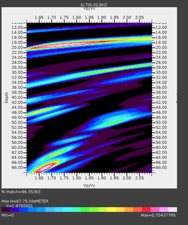
TIXI Tiksi, Russia - Earthquake Result Viewer
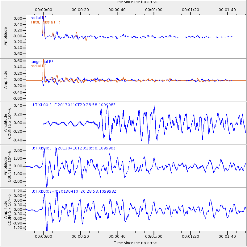
Earthquake location: Philippine Islands Region
Earthquake latitude/longitude: 20.7/122.1
Earthquake time(UTC): 2013/04/10 (100) 20:20:26 GMT
Earthquake Depth: 12 km
Earthquake Magnitude: 5.8 MW, 5.7 MS, 5.9 MW, 6.0 MB
Earthquake Catalog/Contributor: NEIC PDE/NEIC PDE-W
Network: IU Global Seismograph Network (GSN - IRIS/USGS)
Station: TIXI Tiksi, Russia
Lat/Lon: 71.63 N/128.87 E
Elevation: 40 m
Distance: 51.1 deg
Az: 2.766 deg
Baz: 188.194 deg
Ray Param: 0.06763567
Estimated Moho Depth: 67.75 km
Estimated Crust Vp/Vs: 1.68
Assumed Crust Vp: 6.552 km/s
Estimated Crust Vs: 3.912 km/s
Estimated Crust Poisson's Ratio: 0.22
Radial Match: 96.35363 %
Radial Bump: 324
Transverse Match: 92.27974 %
Transverse Bump: 400
SOD ConfigId: 512894
Insert Time: 2013-09-13 04:29:42.809 +0000
GWidth: 2.5
Max Bumps: 400
Tol: 0.001

Signal To Noise

ChannelStoNSTALTA
IU:TIXI:00:BHZ:20130410T20:28:58.109998Z24.9049821.3786816E-65.5357667E-8
IU:TIXI:00:BHN:20130410T20:28:58.109998Z27.0910996.738854E-72.487479E-8
IU:TIXI:00:BHE:20130410T20:28:58.109998Z7.29782772.2166238E-73.0373748E-8
Arrivals
Ps7.4 SECOND
PpPs26 SECOND
PsPs/PpSs33 SECOND