You are here: Home > Network List > UW - Pacific Northwest Regional Seismic Network Stations List
> Station MRBL Marblemount, WA, USA > Earthquake Result Viewer
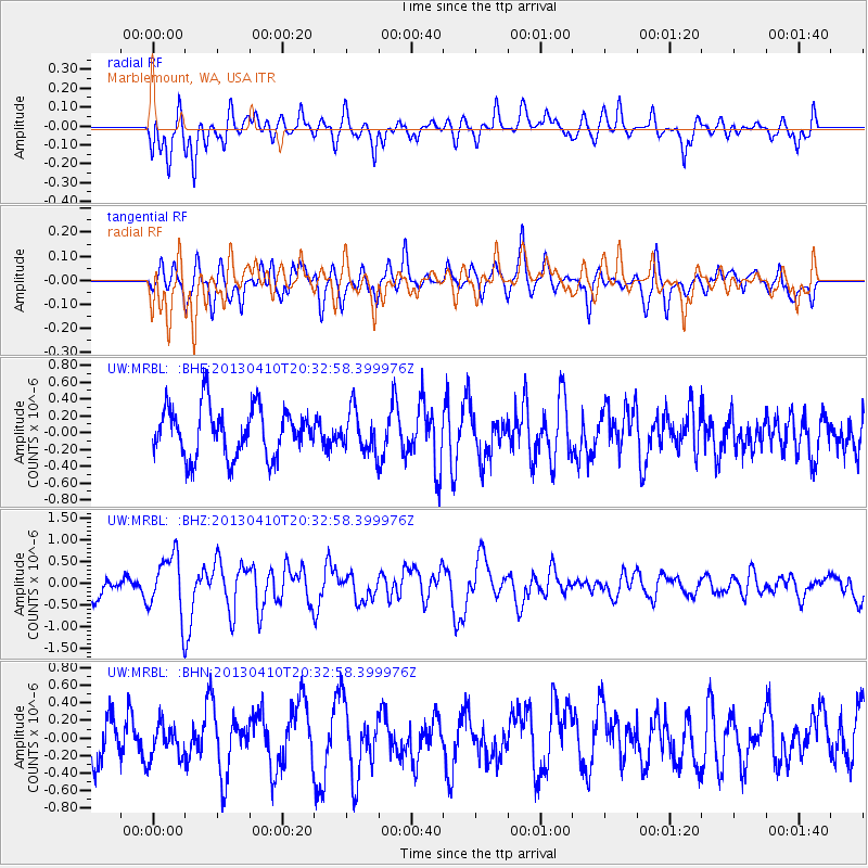
MRBL Marblemount, WA, USA - Earthquake Result Viewer
*The percent match for this event was below the threshold and hence no stack was calculated.
| Earthquake location: |
Philippine Islands Region |
| Earthquake latitude/longitude: |
20.7/122.1 |
| Earthquake time(UTC): |
2013/04/10 (100) 20:20:26 GMT |
| Earthquake Depth: |
12 km |
| Earthquake Magnitude: |
5.8 MW, 5.7 MS, 5.9 MW, 6.0 MB |
| Earthquake Catalog/Contributor: |
NEIC PDE/NEIC PDE-W |
|
| Network: |
UW Pacific Northwest Regional Seismic Network |
| Station: |
MRBL Marblemount, WA, USA |
| Lat/Lon: |
48.52 N/121.48 W |
| Elevation: |
75 m |
|
| Distance: |
90.8 deg |
| Az: |
36.536 deg |
| Baz: |
303.051 deg |
| Ray Param: |
$rayparam |
*The percent match for this event was below the threshold and hence was not used in the summary stack. |
|
| Radial Match: |
62.053932 % |
| Radial Bump: |
400 |
| Transverse Match: |
67.1063 % |
| Transverse Bump: |
400 |
| SOD ConfigId: |
512894 |
| Insert Time: |
2013-09-13 04:36:12.162 +0000 |
| GWidth: |
2.5 |
| Max Bumps: |
400 |
| Tol: |
0.001 |
|
Signal To Noise
| Channel | StoN | STA | LTA |
| UW:MRBL: :BHZ:20130410T20:32:58.399976Z | 1.5881904 | 6.769596E-7 | 4.2624583E-7 |
| UW:MRBL: :BHN:20130410T20:32:58.399976Z | 0.7354825 | 1.9478173E-7 | 2.648353E-7 |
| UW:MRBL: :BHE:20130410T20:32:58.399976Z | 0.829685 | 2.425019E-7 | 2.9228187E-7 |
| Arrivals |
| Ps | |
| PpPs | |
| PsPs/PpSs | |


