You are here: Home > Network List > GS - US Geological Survey Networks Stations List
> Station OK028 N Oak Rd and Britton Rd, Lincoln County > Earthquake Result Viewer
OK028 N Oak Rd and Britton Rd, Lincoln County - Earthquake Result Viewer
| Earthquake location: |
Southeastern Alaska |
| Earthquake latitude/longitude: |
60.4/-140.3 |
| Earthquake time(UTC): |
2014/07/17 (198) 11:49:32 GMT |
| Earthquake Depth: |
0.6 km |
| Earthquake Magnitude: |
5.8 MI |
| Earthquake Catalog/Contributor: |
NEIC PDE/NEIC ALERT |
|
| Network: |
GS US Geological Survey Networks |
| Station: |
OK028 N Oak Rd and Britton Rd, Lincoln County |
| Lat/Lon: |
35.56 N/97.06 W |
| Elevation: |
330 m |
|
| Distance: |
37.1 deg |
| Az: |
112.138 deg |
| Baz: |
325.635 deg |
| Ray Param: |
0.076331645 |
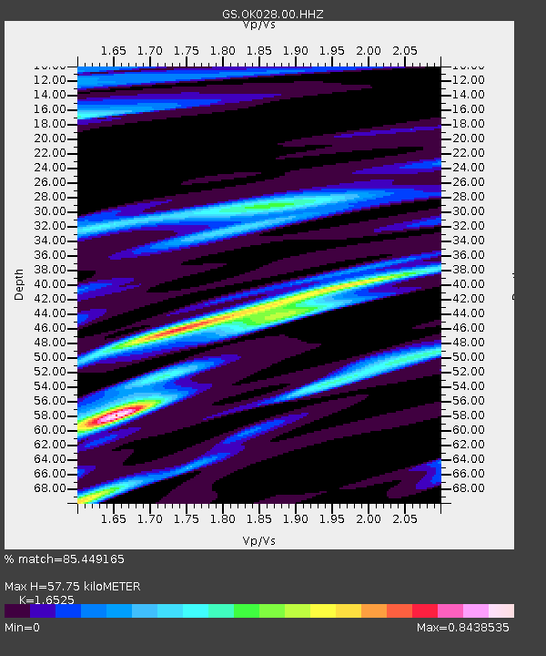
| Estimated Moho Depth: |
57.75 km |
| Estimated Crust Vp/Vs: |
1.65 |
| Assumed Crust Vp: |
6.426 km/s |
| Estimated Crust Vs: |
3.889 km/s |
| Estimated Crust Poisson's Ratio: |
0.21 |
|
| Radial Match: |
85.449165 % |
| Radial Bump: |
337 |
| Transverse Match: |
71.94114 % |
| Transverse Bump: |
400 |
| SOD ConfigId: |
3390531 |
| Insert Time: |
2019-04-12 21:58:44.897 +0000 |
| GWidth: |
2.5 |
| Max Bumps: |
400 |
| Tol: |
0.001 |
|

Signal To Noise
| Channel | StoN | STA | LTA |
| GS:OK028:00:HHZ:20140717T11:56:13.468994Z | 14.22141 | 1.0676983E-6 | 7.507683E-8 |
| GS:OK028:00:HH1:20140717T11:56:13.468994Z | 1.7132523 | 2.9789092E-7 | 1.7387453E-7 |
| GS:OK028:00:HH2:20140717T11:56:13.468994Z | 3.0156822 | 3.6822212E-7 | 1.2210243E-7 |
| Arrivals |
| Ps | 6.3 SECOND |
| PpPs | 22 SECOND |
| PsPs/PpSs | 28 SECOND |


