You are here: Home > Network List > IU - Global Seismograph Network (GSN - IRIS/USGS) Stations List
> Station CTAO Charters Towers, Australia > Earthquake Result Viewer
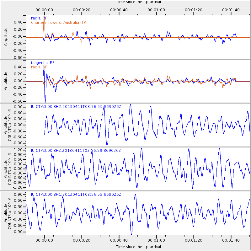
CTAO Charters Towers, Australia - Earthquake Result Viewer
*The percent match for this event was below the threshold and hence no stack was calculated.
| Earthquake location: |
Myanmar |
| Earthquake latitude/longitude: |
19.3/95.6 |
| Earthquake time(UTC): |
2013/04/11 (101) 03:47:02 GMT |
| Earthquake Depth: |
9.9 km |
| Earthquake Magnitude: |
5.5 MB |
| Earthquake Catalog/Contributor: |
NEIC PDE/NEIC PDE-W |
|
| Network: |
IU Global Seismograph Network (GSN - IRIS/USGS) |
| Station: |
CTAO Charters Towers, Australia |
| Lat/Lon: |
20.09 S/146.25 E |
| Elevation: |
357 m |
|
| Distance: |
63.2 deg |
| Az: |
125.486 deg |
| Baz: |
305.071 deg |
| Ray Param: |
$rayparam |
*The percent match for this event was below the threshold and hence was not used in the summary stack. |
|
| Radial Match: |
51.208584 % |
| Radial Bump: |
363 |
| Transverse Match: |
79.91564 % |
| Transverse Bump: |
400 |
| SOD ConfigId: |
512894 |
| Insert Time: |
2013-09-13 04:46:33.070 +0000 |
| GWidth: |
2.5 |
| Max Bumps: |
400 |
| Tol: |
0.001 |
|
Signal To Noise
| Channel | StoN | STA | LTA |
| IU:CTAO:00:BHZ:20130411T03:56:59.869026Z | 0.98709565 | 5.097031E-7 | 5.163665E-7 |
| IU:CTAO:00:BH1:20130411T03:56:59.869026Z | 0.8162131 | 2.9739846E-7 | 3.6436373E-7 |
| IU:CTAO:00:BH2:20130411T03:56:59.869026Z | 2.2825205 | 5.975827E-7 | 2.6180825E-7 |
| Arrivals |
| Ps | |
| PpPs | |
| PsPs/PpSs | |


