You are here: Home > Network List > LD - Lamont-Doherty Cooperative Seismographic Network Stations List
> Station BRNY Black Rock Forest, Cornwall, NY > Earthquake Result Viewer
BRNY Black Rock Forest, Cornwall, NY - Earthquake Result Viewer
| Earthquake location: |
Southeastern Alaska |
| Earthquake latitude/longitude: |
60.4/-140.3 |
| Earthquake time(UTC): |
2014/07/17 (198) 11:49:32 GMT |
| Earthquake Depth: |
0.6 km |
| Earthquake Magnitude: |
5.8 MI |
| Earthquake Catalog/Contributor: |
NEIC PDE/NEIC ALERT |
|
| Network: |
LD Lamont-Doherty Cooperative Seismographic Network |
| Station: |
BRNY Black Rock Forest, Cornwall, NY |
| Lat/Lon: |
41.41 N/74.01 W |
| Elevation: |
248 m |
|
| Distance: |
43.8 deg |
| Az: |
84.577 deg |
| Baz: |
318.881 deg |
| Ray Param: |
0.07235076 |
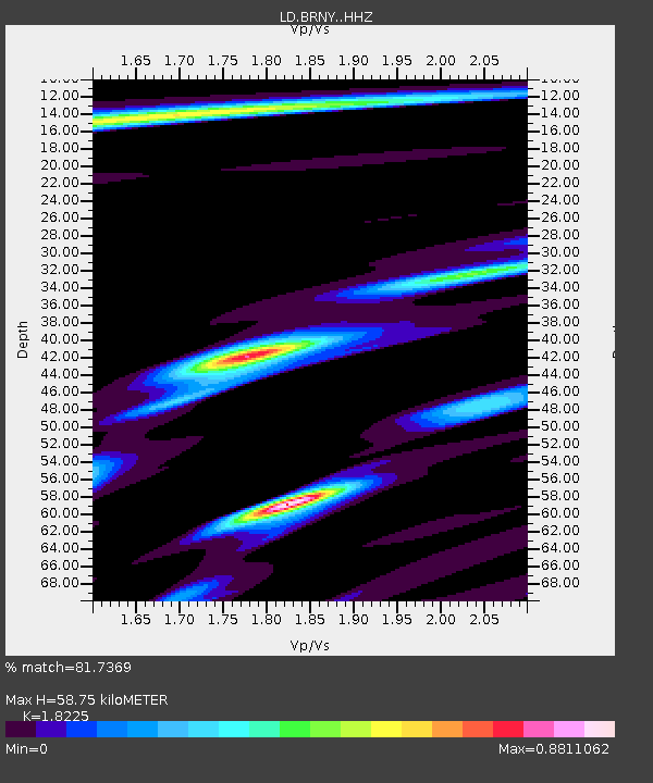
| Estimated Moho Depth: |
58.75 km |
| Estimated Crust Vp/Vs: |
1.82 |
| Assumed Crust Vp: |
6.283 km/s |
| Estimated Crust Vs: |
3.448 km/s |
| Estimated Crust Poisson's Ratio: |
0.28 |
|
| Radial Match: |
81.7369 % |
| Radial Bump: |
276 |
| Transverse Match: |
57.234695 % |
| Transverse Bump: |
400 |
| SOD ConfigId: |
3390531 |
| Insert Time: |
2019-04-12 21:59:30.929 +0000 |
| GWidth: |
2.5 |
| Max Bumps: |
400 |
| Tol: |
0.001 |
|

Signal To Noise
| Channel | StoN | STA | LTA |
| LD:BRNY: :HHZ:20140717T11:57:08.829987Z | 2.1769288 | 4.1977978E-7 | 1.928312E-7 |
| LD:BRNY: :HHN:20140717T11:57:08.829987Z | 1.6029954 | 1.365252E-7 | 8.51688E-8 |
| LD:BRNY: :HHE:20140717T11:57:08.829987Z | 1.1054219 | 2.0193589E-7 | 1.8267765E-7 |
| Arrivals |
| Ps | 8.2 SECOND |
| PpPs | 25 SECOND |
| PsPs/PpSs | 33 SECOND |


