You are here: Home > Network List > NX - Nanometrics Research Network Stations List
> Station STN16 Seismic station 16 > Earthquake Result Viewer
STN16 Seismic station 16 - Earthquake Result Viewer
| Earthquake location: |
Southeastern Alaska |
| Earthquake latitude/longitude: |
60.4/-140.3 |
| Earthquake time(UTC): |
2014/07/17 (198) 11:49:32 GMT |
| Earthquake Depth: |
0.6 km |
| Earthquake Magnitude: |
5.8 MI |
| Earthquake Catalog/Contributor: |
NEIC PDE/NEIC ALERT |
|
| Network: |
NX Nanometrics Research Network |
| Station: |
STN16 Seismic station 16 |
| Lat/Lon: |
36.35 N/97.13 W |
| Elevation: |
294 m |
|
| Distance: |
36.4 deg |
| Az: |
111.465 deg |
| Baz: |
325.057 deg |
| Ray Param: |
0.07670044 |
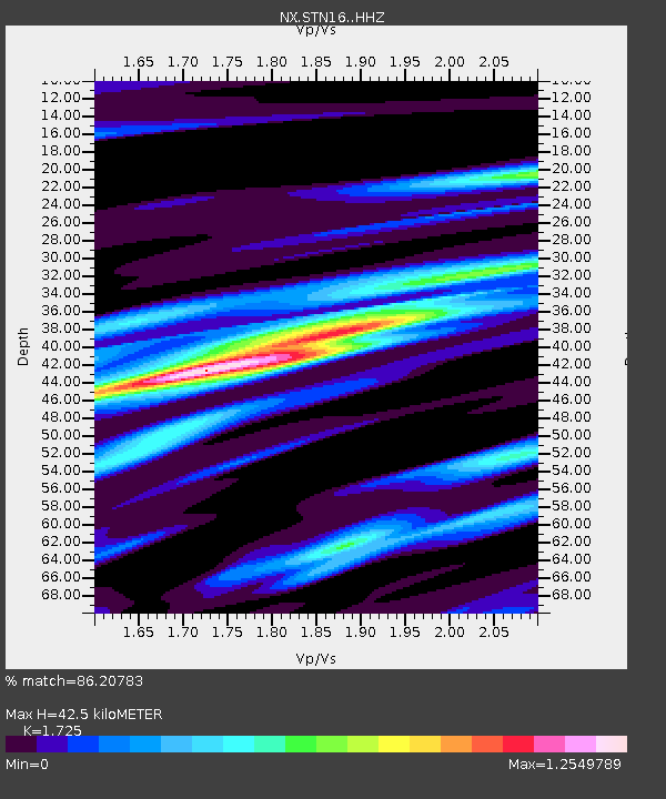
| Estimated Moho Depth: |
42.5 km |
| Estimated Crust Vp/Vs: |
1.73 |
| Assumed Crust Vp: |
6.483 km/s |
| Estimated Crust Vs: |
3.758 km/s |
| Estimated Crust Poisson's Ratio: |
0.25 |
|
| Radial Match: |
86.20783 % |
| Radial Bump: |
286 |
| Transverse Match: |
77.063095 % |
| Transverse Bump: |
400 |
| SOD ConfigId: |
3390531 |
| Insert Time: |
2019-04-12 22:00:25.069 +0000 |
| GWidth: |
2.5 |
| Max Bumps: |
400 |
| Tol: |
0.001 |
|

Signal To Noise
| Channel | StoN | STA | LTA |
| NX:STN16: :HHZ:20140717T11:56:07.720001Z | 13.408944 | 1.2723249E-6 | 9.488628E-8 |
| NX:STN16: :HH1:20140717T11:56:07.720001Z | 5.2860336 | 6.247709E-7 | 1.1819276E-7 |
| NX:STN16: :HH2:20140717T11:56:07.720001Z | 4.0948043 | 4.0422444E-7 | 9.871642E-8 |
| Arrivals |
| Ps | 5.1 SECOND |
| PpPs | 17 SECOND |
| PsPs/PpSs | 22 SECOND |


