You are here: Home > Network List > TA - USArray Transportable Network (new EarthScope stations) Stations List
> Station D62A Allapoint, Allagash, ME, USA > Earthquake Result Viewer
D62A Allapoint, Allagash, ME, USA - Earthquake Result Viewer
| Earthquake location: |
Southeastern Alaska |
| Earthquake latitude/longitude: |
60.4/-140.3 |
| Earthquake time(UTC): |
2014/07/17 (198) 11:49:32 GMT |
| Earthquake Depth: |
0.6 km |
| Earthquake Magnitude: |
5.8 MI |
| Earthquake Catalog/Contributor: |
NEIC PDE/NEIC ALERT |
|
| Network: |
TA USArray Transportable Network (new EarthScope stations) |
| Station: |
D62A Allapoint, Allagash, ME, USA |
| Lat/Lon: |
47.08 N/69.05 W |
| Elevation: |
189 m |
|
| Distance: |
42.1 deg |
| Az: |
75.076 deg |
| Baz: |
315.371 deg |
| Ray Param: |
0.073421754 |
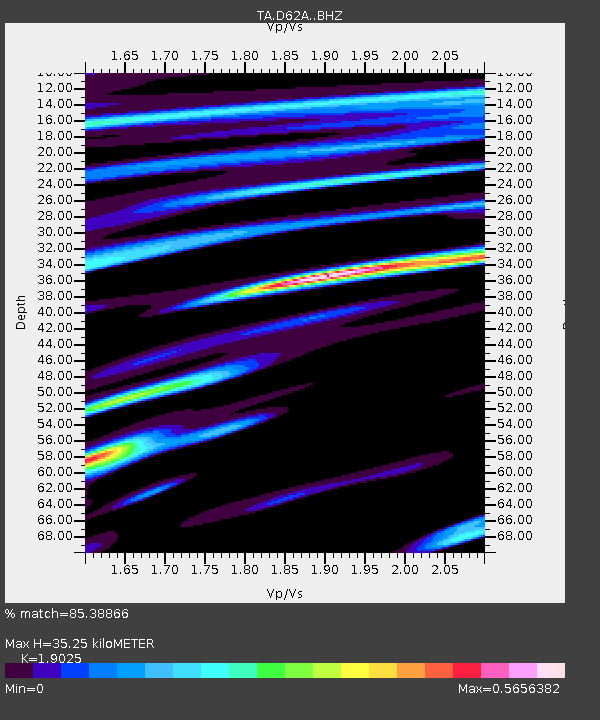
| Estimated Moho Depth: |
35.25 km |
| Estimated Crust Vp/Vs: |
1.90 |
| Assumed Crust Vp: |
6.419 km/s |
| Estimated Crust Vs: |
3.374 km/s |
| Estimated Crust Poisson's Ratio: |
0.31 |
|
| Radial Match: |
85.38866 % |
| Radial Bump: |
336 |
| Transverse Match: |
61.525692 % |
| Transverse Bump: |
400 |
| SOD ConfigId: |
3390531 |
| Insert Time: |
2019-04-12 22:01:15.114 +0000 |
| GWidth: |
2.5 |
| Max Bumps: |
400 |
| Tol: |
0.001 |
|

Signal To Noise
| Channel | StoN | STA | LTA |
| TA:D62A: :BHZ:20140717T11:56:54.949005Z | 1.1070291 | 3.2212532E-7 | 2.909818E-7 |
| TA:D62A: :BHN:20140717T11:56:54.949005Z | 1.2906106 | 1.6692967E-7 | 1.2934163E-7 |
| TA:D62A: :BHE:20140717T11:56:54.949005Z | 0.7685124 | 1.3521083E-7 | 1.7593837E-7 |
| Arrivals |
| Ps | 5.3 SECOND |
| PpPs | 15 SECOND |
| PsPs/PpSs | 20 SECOND |


