You are here: Home > Network List > TA - USArray Transportable Network (new EarthScope stations) Stations List
> Station I55A Frankford, ON, CAN > Earthquake Result Viewer
I55A Frankford, ON, CAN - Earthquake Result Viewer
| Earthquake location: |
Southeastern Alaska |
| Earthquake latitude/longitude: |
60.4/-140.3 |
| Earthquake time(UTC): |
2014/07/17 (198) 11:49:32 GMT |
| Earthquake Depth: |
0.6 km |
| Earthquake Magnitude: |
5.8 MI |
| Earthquake Catalog/Contributor: |
NEIC PDE/NEIC ALERT |
|
| Network: |
TA USArray Transportable Network (new EarthScope stations) |
| Station: |
I55A Frankford, ON, CAN |
| Lat/Lon: |
44.22 N/77.68 W |
| Elevation: |
132 m |
|
| Distance: |
39.9 deg |
| Az: |
84.746 deg |
| Baz: |
316.521 deg |
| Ray Param: |
0.074737296 |
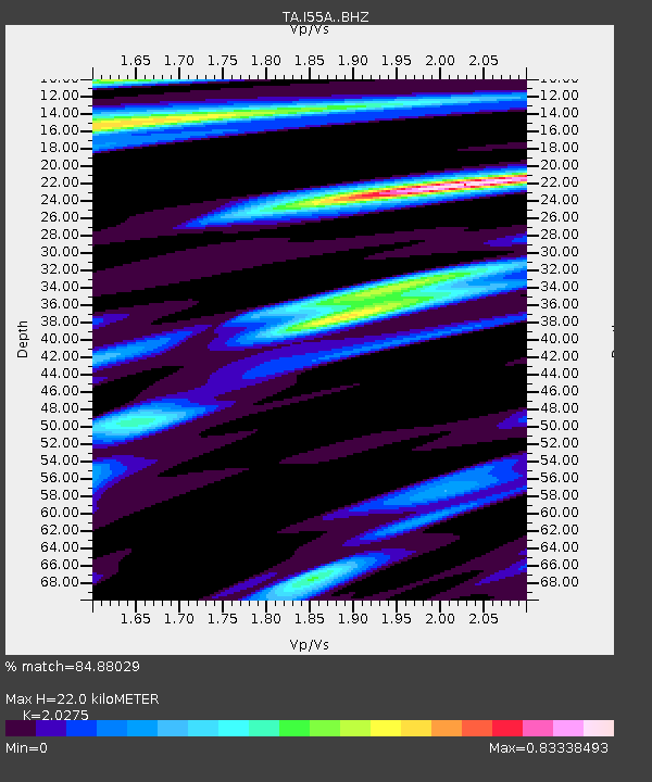
| Estimated Moho Depth: |
22.0 km |
| Estimated Crust Vp/Vs: |
2.03 |
| Assumed Crust Vp: |
6.577 km/s |
| Estimated Crust Vs: |
3.244 km/s |
| Estimated Crust Poisson's Ratio: |
0.34 |
|
| Radial Match: |
84.88029 % |
| Radial Bump: |
274 |
| Transverse Match: |
58.505165 % |
| Transverse Bump: |
400 |
| SOD ConfigId: |
3390531 |
| Insert Time: |
2019-04-12 22:01:25.383 +0000 |
| GWidth: |
2.5 |
| Max Bumps: |
400 |
| Tol: |
0.001 |
|
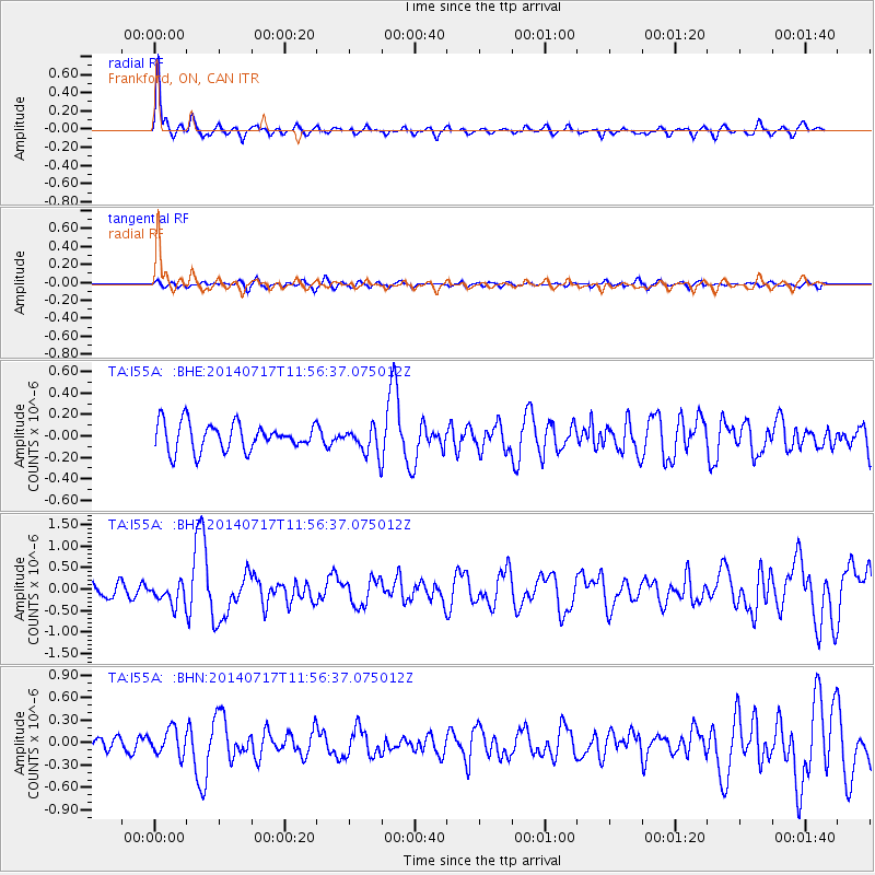
Signal To Noise
| Channel | StoN | STA | LTA |
| TA:I55A: :BHZ:20140717T11:56:37.075012Z | 1.5033568 | 2.5250586E-7 | 1.6796136E-7 |
| TA:I55A: :BHN:20140717T11:56:37.075012Z | 1.3325454 | 1.7094737E-7 | 1.2828633E-7 |
| TA:I55A: :BHE:20140717T11:56:37.075012Z | 0.75187445 | 9.481938E-8 | 1.2611065E-7 |
| Arrivals |
| Ps | 3.7 SECOND |
| PpPs | 9.5 SECOND |
| PsPs/PpSs | 13 SECOND |


