You are here: Home > Network List > CI - Caltech Regional Seismic Network Stations List
> Station SLA SLA, Trona, CA, USA > Earthquake Result Viewer
SLA SLA, Trona, CA, USA - Earthquake Result Viewer
| Earthquake location: |
Chile-Bolivia Border Region |
| Earthquake latitude/longitude: |
-21.7/-68.3 |
| Earthquake time(UTC): |
2002/03/28 (087) 04:56:22 GMT |
| Earthquake Depth: |
125 km |
| Earthquake Magnitude: |
6.1 MB, 6.5 MW, 6.5 MW |
| Earthquake Catalog/Contributor: |
WHDF/NEIC |
|
| Network: |
CI Caltech Regional Seismic Network |
| Station: |
SLA SLA, Trona, CA, USA |
| Lat/Lon: |
35.89 N/117.28 W |
| Elevation: |
1174 m |
|
| Distance: |
73.6 deg |
| Az: |
320.338 deg |
| Baz: |
133.014 deg |
| Ray Param: |
0.052560546 |
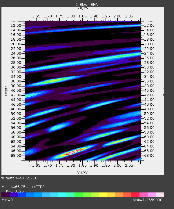
| Estimated Moho Depth: |
66.25 km |
| Estimated Crust Vp/Vs: |
1.81 |
| Assumed Crust Vp: |
6.276 km/s |
| Estimated Crust Vs: |
3.463 km/s |
| Estimated Crust Poisson's Ratio: |
0.28 |
|
| Radial Match: |
94.55718 % |
| Radial Bump: |
400 |
| Transverse Match: |
90.121315 % |
| Transverse Bump: |
400 |
| SOD ConfigId: |
3787 |
| Insert Time: |
2010-02-25 20:30:00.173 +0000 |
| GWidth: |
2.5 |
| Max Bumps: |
400 |
| Tol: |
0.001 |
|
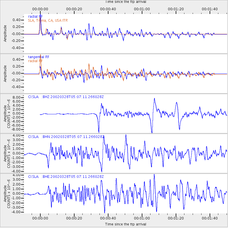
Signal To Noise
| Channel | StoN | STA | LTA |
| CI:SLA: :BHN:20020328T05:07:11.266028Z | 5.554693 | 8.755052E-7 | 1.5761539E-7 |
| CI:SLA: :BHE:20020328T05:07:11.266028Z | 1.9984131 | 4.38153E-7 | 2.1925047E-7 |
| CI:SLA: :BHZ:20020328T05:07:11.266028Z | 23.963026 | 2.8211095E-6 | 1.17727595E-7 |
| Arrivals |
| Ps | 8.8 SECOND |
| PpPs | 29 SECOND |
| PsPs/PpSs | 38 SECOND |


