You are here: Home > Network List > TA - USArray Transportable Network (new EarthScope stations) Stations List
> Station I60A Shoreham, VT, USA > Earthquake Result Viewer
I60A Shoreham, VT, USA - Earthquake Result Viewer
| Earthquake location: |
Southeastern Alaska |
| Earthquake latitude/longitude: |
60.4/-140.3 |
| Earthquake time(UTC): |
2014/07/17 (198) 11:49:32 GMT |
| Earthquake Depth: |
0.6 km |
| Earthquake Magnitude: |
5.8 MI |
| Earthquake Catalog/Contributor: |
NEIC PDE/NEIC ALERT |
|
| Network: |
TA USArray Transportable Network (new EarthScope stations) |
| Station: |
I60A Shoreham, VT, USA |
| Lat/Lon: |
43.84 N/73.29 W |
| Elevation: |
101 m |
|
| Distance: |
42.3 deg |
| Az: |
81.62 deg |
| Baz: |
317.206 deg |
| Ray Param: |
0.0732559 |
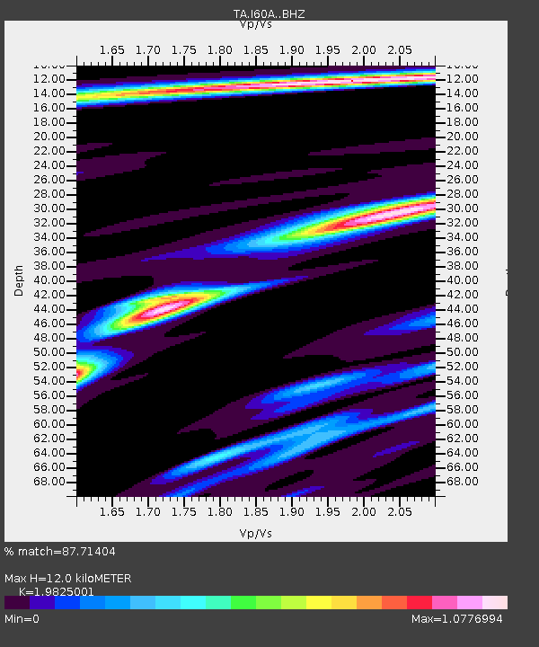
| Estimated Moho Depth: |
12.0 km |
| Estimated Crust Vp/Vs: |
1.98 |
| Assumed Crust Vp: |
6.419 km/s |
| Estimated Crust Vs: |
3.238 km/s |
| Estimated Crust Poisson's Ratio: |
0.33 |
|
| Radial Match: |
87.71404 % |
| Radial Bump: |
257 |
| Transverse Match: |
62.681797 % |
| Transverse Bump: |
301 |
| SOD ConfigId: |
3390531 |
| Insert Time: |
2019-04-12 22:01:26.107 +0000 |
| GWidth: |
2.5 |
| Max Bumps: |
400 |
| Tol: |
0.001 |
|

Signal To Noise
| Channel | StoN | STA | LTA |
| TA:I60A: :BHZ:20140717T11:56:57.149994Z | 1.8345762 | 3.82568E-7 | 2.0853207E-7 |
| TA:I60A: :BHN:20140717T11:56:57.149994Z | 1.6575545 | 2.1778659E-7 | 1.3139031E-7 |
| TA:I60A: :BHE:20140717T11:56:57.149994Z | 1.9395381 | 2.5773323E-7 | 1.3288381E-7 |
| Arrivals |
| Ps | 2.0 SECOND |
| PpPs | 5.3 SECOND |
| PsPs/PpSs | 7.2 SECOND |


