You are here: Home > Network List > TA - USArray Transportable Network (new EarthScope stations) Stations List
> Station J60A Lant Hill Farm, Argyle, NY, USA > Earthquake Result Viewer
J60A Lant Hill Farm, Argyle, NY, USA - Earthquake Result Viewer
| Earthquake location: |
Southeastern Alaska |
| Earthquake latitude/longitude: |
60.4/-140.3 |
| Earthquake time(UTC): |
2014/07/17 (198) 11:49:32 GMT |
| Earthquake Depth: |
0.6 km |
| Earthquake Magnitude: |
5.8 MI |
| Earthquake Catalog/Contributor: |
NEIC PDE/NEIC ALERT |
|
| Network: |
TA USArray Transportable Network (new EarthScope stations) |
| Station: |
J60A Lant Hill Farm, Argyle, NY, USA |
| Lat/Lon: |
43.24 N/73.42 W |
| Elevation: |
265 m |
|
| Distance: |
42.7 deg |
| Az: |
82.323 deg |
| Baz: |
317.635 deg |
| Ray Param: |
0.07303609 |
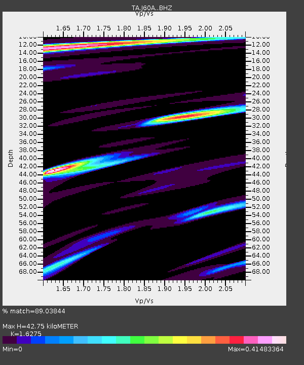
| Estimated Moho Depth: |
42.75 km |
| Estimated Crust Vp/Vs: |
1.63 |
| Assumed Crust Vp: |
6.419 km/s |
| Estimated Crust Vs: |
3.944 km/s |
| Estimated Crust Poisson's Ratio: |
0.20 |
|
| Radial Match: |
89.03844 % |
| Radial Bump: |
217 |
| Transverse Match: |
48.98499 % |
| Transverse Bump: |
400 |
| SOD ConfigId: |
3390531 |
| Insert Time: |
2019-04-12 22:01:28.597 +0000 |
| GWidth: |
2.5 |
| Max Bumps: |
400 |
| Tol: |
0.001 |
|

Signal To Noise
| Channel | StoN | STA | LTA |
| TA:J60A: :BHZ:20140717T11:57:00.200012Z | 2.022304 | 2.901876E-7 | 1.4349355E-7 |
| TA:J60A: :BHN:20140717T11:57:00.200012Z | 1.9473461 | 1.7474795E-7 | 8.973646E-8 |
| TA:J60A: :BHE:20140717T11:57:00.200012Z | 1.4266711 | 1.7041533E-7 | 1.1944962E-7 |
| Arrivals |
| Ps | 4.5 SECOND |
| PpPs | 16 SECOND |
| PsPs/PpSs | 21 SECOND |


