You are here: Home > Network List > TA - USArray Transportable Network (new EarthScope stations) Stations List
> Station T57A Hurt, VA, USA > Earthquake Result Viewer
T57A Hurt, VA, USA - Earthquake Result Viewer
| Earthquake location: |
Southeastern Alaska |
| Earthquake latitude/longitude: |
60.4/-140.3 |
| Earthquake time(UTC): |
2014/07/17 (198) 11:49:32 GMT |
| Earthquake Depth: |
0.6 km |
| Earthquake Magnitude: |
5.8 MI |
| Earthquake Catalog/Contributor: |
NEIC PDE/NEIC ALERT |
|
| Network: |
TA USArray Transportable Network (new EarthScope stations) |
| Station: |
T57A Hurt, VA, USA |
| Lat/Lon: |
37.00 N/79.25 W |
| Elevation: |
230 m |
|
| Distance: |
44.6 deg |
| Az: |
93.116 deg |
| Baz: |
321.706 deg |
| Ray Param: |
0.07185501 |
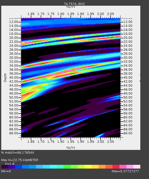
| Estimated Moho Depth: |
22.75 km |
| Estimated Crust Vp/Vs: |
1.60 |
| Assumed Crust Vp: |
6.419 km/s |
| Estimated Crust Vs: |
4.012 km/s |
| Estimated Crust Poisson's Ratio: |
0.18 |
|
| Radial Match: |
86.176544 % |
| Radial Bump: |
296 |
| Transverse Match: |
39.312687 % |
| Transverse Bump: |
400 |
| SOD ConfigId: |
3390531 |
| Insert Time: |
2019-04-12 22:01:44.342 +0000 |
| GWidth: |
2.5 |
| Max Bumps: |
400 |
| Tol: |
0.001 |
|
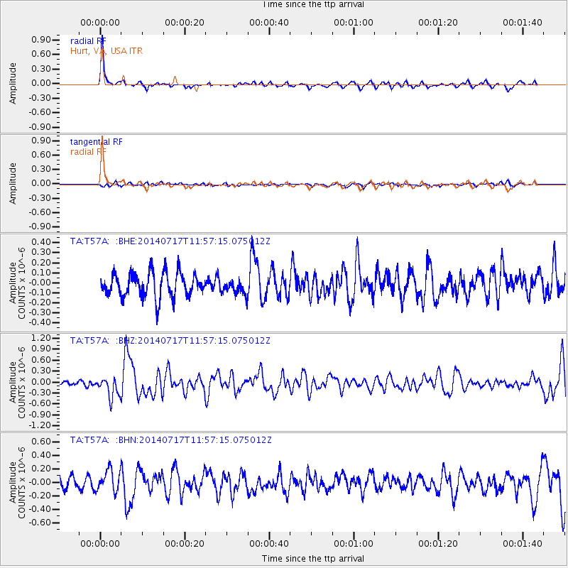
Signal To Noise
| Channel | StoN | STA | LTA |
| TA:T57A: :BHZ:20140717T11:57:15.075012Z | 2.1363156 | 2.8645184E-7 | 1.3408685E-7 |
| TA:T57A: :BHN:20140717T11:57:15.075012Z | 1.6556218 | 1.6530325E-7 | 9.9843604E-8 |
| TA:T57A: :BHE:20140717T11:57:15.075012Z | 0.5030329 | 6.151139E-8 | 1.2228105E-7 |
| Arrivals |
| Ps | 2.3 SECOND |
| PpPs | 8.6 SECOND |
| PsPs/PpSs | 11 SECOND |


