You are here: Home > Network List > II - Global Seismograph Network (GSN - IRIS/IDA) Stations List
> Station WRAB Tennant Creek, NT, Australia > Earthquake Result Viewer
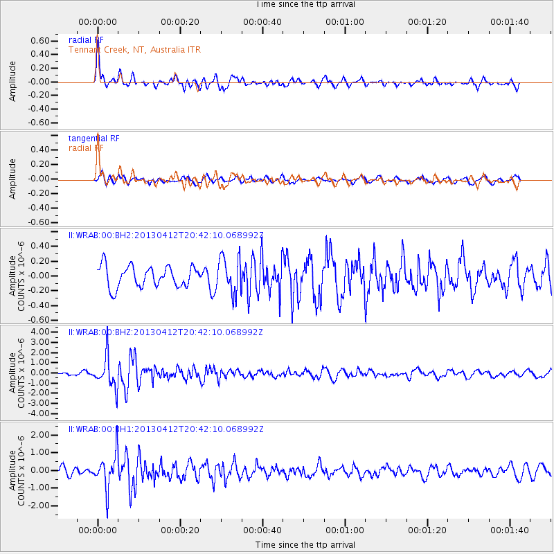
WRAB Tennant Creek, NT, Australia - Earthquake Result Viewer
*The percent match for this event was below the threshold and hence no stack was calculated.
| Earthquake location: |
Near S. Coast Of Western Honshu |
| Earthquake latitude/longitude: |
34.4/134.8 |
| Earthquake time(UTC): |
2013/04/12 (102) 20:33:17 GMT |
| Earthquake Depth: |
14 km |
| Earthquake Magnitude: |
5.8 MW, 5.5 MS, 5.7 MB, 5.8 MW |
| Earthquake Catalog/Contributor: |
NEIC PDE/NEIC PDE-W |
|
| Network: |
II Global Seismograph Network (GSN - IRIS/IDA) |
| Station: |
WRAB Tennant Creek, NT, Australia |
| Lat/Lon: |
19.93 S/134.36 E |
| Elevation: |
366 m |
|
| Distance: |
54.0 deg |
| Az: |
180.544 deg |
| Baz: |
0.478 deg |
| Ray Param: |
$rayparam |
*The percent match for this event was below the threshold and hence was not used in the summary stack. |
|
| Radial Match: |
71.61581 % |
| Radial Bump: |
396 |
| Transverse Match: |
68.97347 % |
| Transverse Bump: |
400 |
| SOD ConfigId: |
512894 |
| Insert Time: |
2013-09-13 05:29:45.805 +0000 |
| GWidth: |
2.5 |
| Max Bumps: |
400 |
| Tol: |
0.001 |
|
Signal To Noise
| Channel | StoN | STA | LTA |
| II:WRAB:00:BHZ:20130412T20:42:10.068992Z | 8.920554 | 1.6123262E-6 | 1.8074282E-7 |
| II:WRAB:00:BH1:20130412T20:42:10.068992Z | 4.8899026 | 1.0337177E-6 | 2.1139842E-7 |
| II:WRAB:00:BH2:20130412T20:42:10.068992Z | 1.7375344 | 2.4557613E-7 | 1.4133599E-7 |
| Arrivals |
| Ps | |
| PpPs | |
| PsPs/PpSs | |


