You are here: Home > Network List > IW - Intermountain West Stations List
> Station DLMT Dillon, Montana, USA > Earthquake Result Viewer
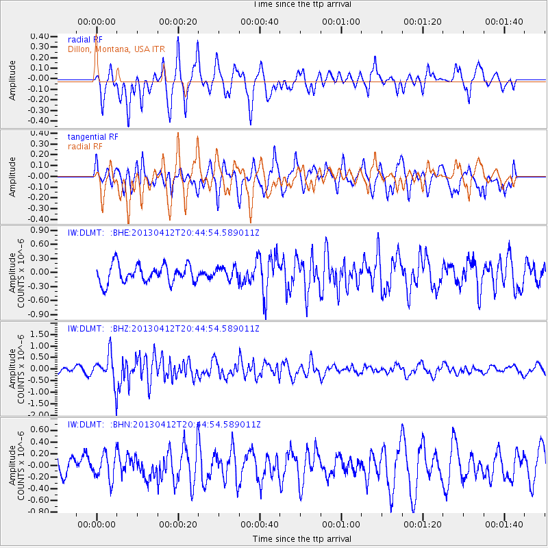
DLMT Dillon, Montana, USA - Earthquake Result Viewer
*The percent match for this event was below the threshold and hence no stack was calculated.
| Earthquake location: |
Near S. Coast Of Western Honshu |
| Earthquake latitude/longitude: |
34.4/134.8 |
| Earthquake time(UTC): |
2013/04/12 (102) 20:33:17 GMT |
| Earthquake Depth: |
14 km |
| Earthquake Magnitude: |
5.8 MW, 5.5 MS, 5.7 MB, 5.8 MW |
| Earthquake Catalog/Contributor: |
NEIC PDE/NEIC PDE-W |
|
| Network: |
IW Intermountain West |
| Station: |
DLMT Dillon, Montana, USA |
| Lat/Lon: |
45.36 N/112.60 W |
| Elevation: |
1569 m |
|
| Distance: |
79.9 deg |
| Az: |
41.387 deg |
| Baz: |
309.13 deg |
| Ray Param: |
$rayparam |
*The percent match for this event was below the threshold and hence was not used in the summary stack. |
|
| Radial Match: |
68.09036 % |
| Radial Bump: |
400 |
| Transverse Match: |
71.221245 % |
| Transverse Bump: |
400 |
| SOD ConfigId: |
512894 |
| Insert Time: |
2013-09-13 05:31:49.956 +0000 |
| GWidth: |
2.5 |
| Max Bumps: |
400 |
| Tol: |
0.001 |
|
Signal To Noise
| Channel | StoN | STA | LTA |
| IW:DLMT: :BHZ:20130412T20:44:54.589011Z | 6.624201 | 6.39265E-7 | 9.650448E-8 |
| IW:DLMT: :BHN:20130412T20:44:54.589011Z | 1.2043496 | 2.2745493E-7 | 1.8886122E-7 |
| IW:DLMT: :BHE:20130412T20:44:54.589011Z | 0.7068142 | 1.3590241E-7 | 1.9227457E-7 |
| Arrivals |
| Ps | |
| PpPs | |
| PsPs/PpSs | |


