You are here: Home > Network List > TA - USArray Transportable Network (new EarthScope stations) Stations List
> Station G43A Wallace, MI, USA > Earthquake Result Viewer
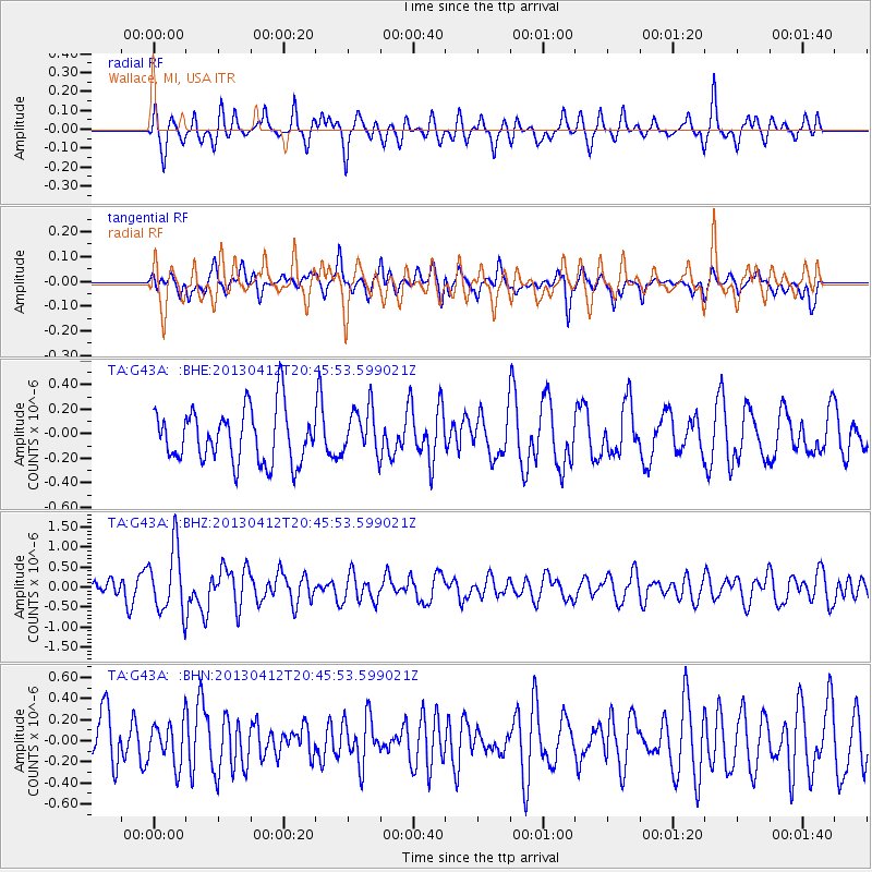
G43A Wallace, MI, USA - Earthquake Result Viewer
*The percent match for this event was below the threshold and hence no stack was calculated.
| Earthquake location: |
Near S. Coast Of Western Honshu |
| Earthquake latitude/longitude: |
34.4/134.8 |
| Earthquake time(UTC): |
2013/04/12 (102) 20:33:17 GMT |
| Earthquake Depth: |
14 km |
| Earthquake Magnitude: |
5.8 MW, 5.5 MS, 5.7 MB, 5.8 MW |
| Earthquake Catalog/Contributor: |
NEIC PDE/NEIC PDE-W |
|
| Network: |
TA USArray Transportable Network (new EarthScope stations) |
| Station: |
G43A Wallace, MI, USA |
| Lat/Lon: |
45.26 N/87.69 W |
| Elevation: |
213 m |
|
| Distance: |
91.9 deg |
| Az: |
28.526 deg |
| Baz: |
325.994 deg |
| Ray Param: |
$rayparam |
*The percent match for this event was below the threshold and hence was not used in the summary stack. |
|
| Radial Match: |
56.6376 % |
| Radial Bump: |
340 |
| Transverse Match: |
50.471897 % |
| Transverse Bump: |
300 |
| SOD ConfigId: |
512894 |
| Insert Time: |
2013-09-13 05:43:17.042 +0000 |
| GWidth: |
2.5 |
| Max Bumps: |
400 |
| Tol: |
0.001 |
|
Signal To Noise
| Channel | StoN | STA | LTA |
| TA:G43A: :BHZ:20130412T20:45:53.599021Z | 3.6459095 | 8.0605844E-7 | 2.210857E-7 |
| TA:G43A: :BHN:20130412T20:45:53.599021Z | 0.64431006 | 2.0062507E-7 | 3.113797E-7 |
| TA:G43A: :BHE:20130412T20:45:53.599021Z | 0.8886219 | 1.9224885E-7 | 2.1634493E-7 |
| Arrivals |
| Ps | |
| PpPs | |
| PsPs/PpSs | |


