You are here: Home > Network List > US - United States National Seismic Network Stations List
> Station BOZ Bozeman, Montana, USA > Earthquake Result Viewer
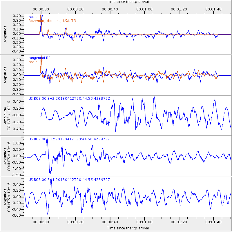
BOZ Bozeman, Montana, USA - Earthquake Result Viewer
*The percent match for this event was below the threshold and hence no stack was calculated.
| Earthquake location: |
Near S. Coast Of Western Honshu |
| Earthquake latitude/longitude: |
34.4/134.8 |
| Earthquake time(UTC): |
2013/04/12 (102) 20:33:17 GMT |
| Earthquake Depth: |
14 km |
| Earthquake Magnitude: |
5.8 MW, 5.5 MS, 5.7 MB, 5.8 MW |
| Earthquake Catalog/Contributor: |
NEIC PDE/NEIC PDE-W |
|
| Network: |
US United States National Seismic Network |
| Station: |
BOZ Bozeman, Montana, USA |
| Lat/Lon: |
45.65 N/111.63 W |
| Elevation: |
1589 m |
|
| Distance: |
80.3 deg |
| Az: |
40.726 deg |
| Baz: |
309.704 deg |
| Ray Param: |
$rayparam |
*The percent match for this event was below the threshold and hence was not used in the summary stack. |
|
| Radial Match: |
70.23646 % |
| Radial Bump: |
400 |
| Transverse Match: |
64.807304 % |
| Transverse Bump: |
400 |
| SOD ConfigId: |
512894 |
| Insert Time: |
2013-09-13 05:52:07.280 +0000 |
| GWidth: |
2.5 |
| Max Bumps: |
400 |
| Tol: |
0.001 |
|
Signal To Noise
| Channel | StoN | STA | LTA |
| US:BOZ:00:BHZ:20130412T20:44:56.423972Z | 2.9754462 | 5.75354E-7 | 1.9336731E-7 |
| US:BOZ:00:BH1:20130412T20:44:56.423972Z | 1.4461852 | 2.2598769E-7 | 1.5626469E-7 |
| US:BOZ:00:BH2:20130412T20:44:56.423972Z | 0.9618507 | 1.245601E-7 | 1.2950046E-7 |
| Arrivals |
| Ps | |
| PpPs | |
| PsPs/PpSs | |


