You are here: Home > Network List > US - United States National Seismic Network Stations List
> Station OGNE Ogallala, Nebraska, USA > Earthquake Result Viewer
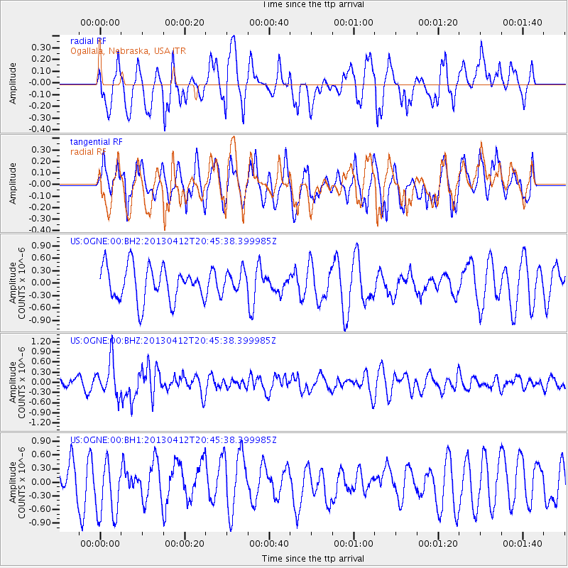
OGNE Ogallala, Nebraska, USA - Earthquake Result Viewer
*The percent match for this event was below the threshold and hence no stack was calculated.
| Earthquake location: |
Near S. Coast Of Western Honshu |
| Earthquake latitude/longitude: |
34.4/134.8 |
| Earthquake time(UTC): |
2013/04/12 (102) 20:33:17 GMT |
| Earthquake Depth: |
14 km |
| Earthquake Magnitude: |
5.8 MW, 5.5 MS, 5.7 MB, 5.8 MW |
| Earthquake Catalog/Contributor: |
NEIC PDE/NEIC PDE-W |
|
| Network: |
US United States National Seismic Network |
| Station: |
OGNE Ogallala, Nebraska, USA |
| Lat/Lon: |
40.95 N/102.03 W |
| Elevation: |
0.0 m |
|
| Distance: |
88.6 deg |
| Az: |
39.382 deg |
| Baz: |
316.145 deg |
| Ray Param: |
$rayparam |
*The percent match for this event was below the threshold and hence was not used in the summary stack. |
|
| Radial Match: |
41.096462 % |
| Radial Bump: |
400 |
| Transverse Match: |
50.392265 % |
| Transverse Bump: |
400 |
| SOD ConfigId: |
512894 |
| Insert Time: |
2013-09-13 05:53:22.184 +0000 |
| GWidth: |
2.5 |
| Max Bumps: |
400 |
| Tol: |
0.001 |
|
Signal To Noise
| Channel | StoN | STA | LTA |
| US:OGNE:00:BHZ:20130412T20:45:38.399985Z | 2.3887038 | 5.385927E-7 | 2.2547488E-7 |
| US:OGNE:00:BH1:20130412T20:45:38.399985Z | 1.7412541 | 6.2027647E-7 | 3.5622398E-7 |
| US:OGNE:00:BH2:20130412T20:45:38.399985Z | 0.59957737 | 2.4924043E-7 | 4.156935E-7 |
| Arrivals |
| Ps | |
| PpPs | |
| PsPs/PpSs | |


