You are here: Home > Network List > TA - USArray Transportable Network (new EarthScope stations) Stations List
> Station 121A Cookes Peak, Deming, NM, USA > Earthquake Result Viewer
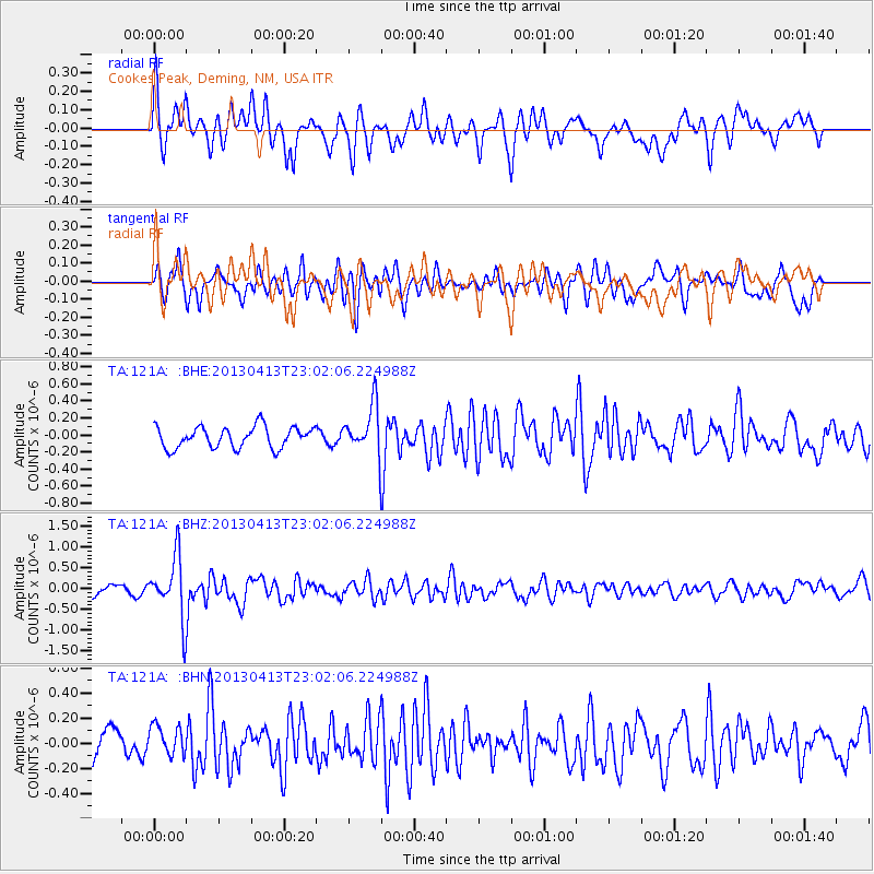
121A Cookes Peak, Deming, NM, USA - Earthquake Result Viewer
*The percent match for this event was below the threshold and hence no stack was calculated.
| Earthquake location: |
Vanuatu Islands |
| Earthquake latitude/longitude: |
-19.1/169.5 |
| Earthquake time(UTC): |
2013/04/13 (103) 22:49:50 GMT |
| Earthquake Depth: |
280 km |
| Earthquake Magnitude: |
6.0 MW, 5.9 MB, 6.0 MW |
| Earthquake Catalog/Contributor: |
NEIC PDE/NEIC PDE-W |
|
| Network: |
TA USArray Transportable Network (new EarthScope stations) |
| Station: |
121A Cookes Peak, Deming, NM, USA |
| Lat/Lon: |
32.53 N/107.79 W |
| Elevation: |
1652 m |
|
| Distance: |
94.2 deg |
| Az: |
57.146 deg |
| Baz: |
250.081 deg |
| Ray Param: |
$rayparam |
*The percent match for this event was below the threshold and hence was not used in the summary stack. |
|
| Radial Match: |
75.82044 % |
| Radial Bump: |
400 |
| Transverse Match: |
69.744606 % |
| Transverse Bump: |
400 |
| SOD ConfigId: |
512894 |
| Insert Time: |
2013-09-13 06:17:25.378 +0000 |
| GWidth: |
2.5 |
| Max Bumps: |
400 |
| Tol: |
0.001 |
|
Signal To Noise
| Channel | StoN | STA | LTA |
| TA:121A: :BHZ:20130413T23:02:06.224988Z | 5.158852 | 7.2939537E-7 | 1.4138715E-7 |
| TA:121A: :BHN:20130413T23:02:06.224988Z | 1.0424763 | 1.2271036E-7 | 1.17710464E-7 |
| TA:121A: :BHE:20130413T23:02:06.224988Z | 2.2854745 | 2.8307008E-7 | 1.2385615E-7 |
| Arrivals |
| Ps | |
| PpPs | |
| PsPs/PpSs | |


