You are here: Home > Network List > US - United States National Seismic Network Stations List
> Station DUG Dugway, Tooele County, Utah, USA > Earthquake Result Viewer
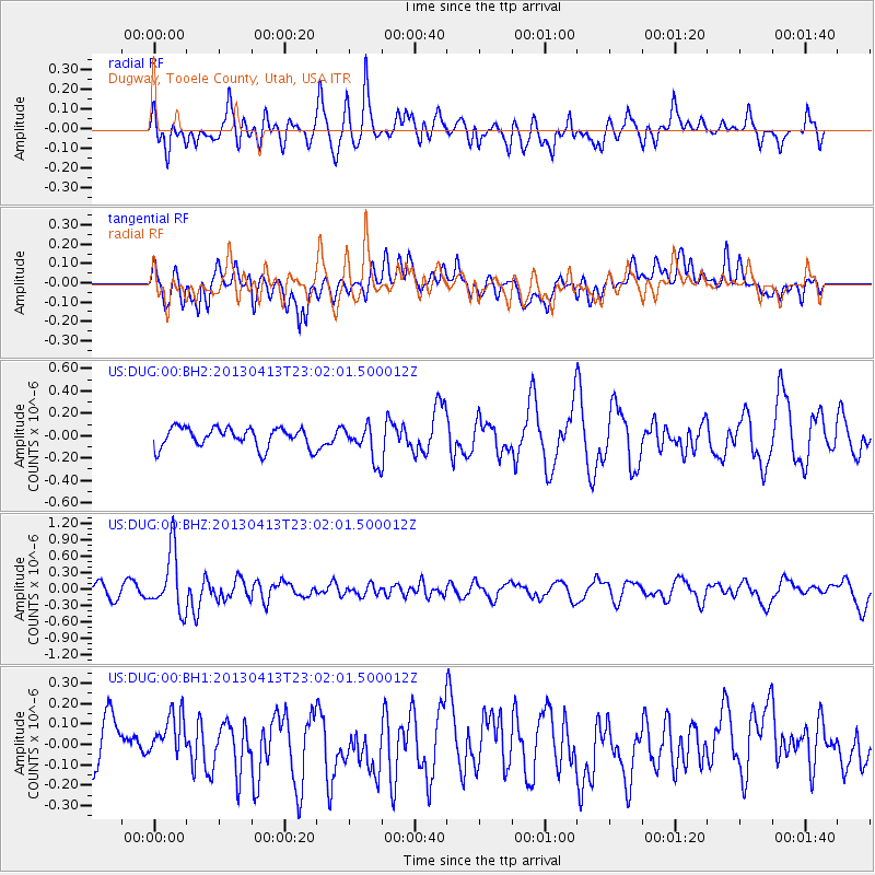
DUG Dugway, Tooele County, Utah, USA - Earthquake Result Viewer
*The percent match for this event was below the threshold and hence no stack was calculated.
| Earthquake location: |
Vanuatu Islands |
| Earthquake latitude/longitude: |
-19.1/169.5 |
| Earthquake time(UTC): |
2013/04/13 (103) 22:49:50 GMT |
| Earthquake Depth: |
280 km |
| Earthquake Magnitude: |
6.0 MW, 5.9 MB, 6.0 MW |
| Earthquake Catalog/Contributor: |
NEIC PDE/NEIC PDE-W |
|
| Network: |
US United States National Seismic Network |
| Station: |
DUG Dugway, Tooele County, Utah, USA |
| Lat/Lon: |
40.19 N/112.81 W |
| Elevation: |
1477 m |
|
| Distance: |
93.1 deg |
| Az: |
48.537 deg |
| Baz: |
247.654 deg |
| Ray Param: |
$rayparam |
*The percent match for this event was below the threshold and hence was not used in the summary stack. |
|
| Radial Match: |
54.607967 % |
| Radial Bump: |
400 |
| Transverse Match: |
38.15871 % |
| Transverse Bump: |
400 |
| SOD ConfigId: |
512894 |
| Insert Time: |
2013-09-13 06:20:34.087 +0000 |
| GWidth: |
2.5 |
| Max Bumps: |
400 |
| Tol: |
0.001 |
|
Signal To Noise
| Channel | StoN | STA | LTA |
| US:DUG:00:BHZ:20130413T23:02:01.500012Z | 5.5752563 | 5.424295E-7 | 9.729231E-8 |
| US:DUG:00:BH1:20130413T23:02:01.500012Z | 0.86265206 | 1.1631647E-7 | 1.348359E-7 |
| US:DUG:00:BH2:20130413T23:02:01.500012Z | 1.7385958 | 1.5532095E-7 | 8.9337E-8 |
| Arrivals |
| Ps | |
| PpPs | |
| PsPs/PpSs | |


