You are here: Home > Network List > UW - Pacific Northwest Regional Seismic Network Stations List
> Station HOOD Mt Hood Meadows, OR CREST BB SMO > Earthquake Result Viewer
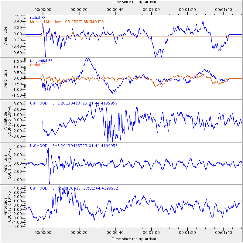
HOOD Mt Hood Meadows, OR CREST BB SMO - Earthquake Result Viewer
*The percent match for this event was below the threshold and hence no stack was calculated.
| Earthquake location: |
Vanuatu Islands |
| Earthquake latitude/longitude: |
-19.1/169.5 |
| Earthquake time(UTC): |
2013/04/13 (103) 22:49:50 GMT |
| Earthquake Depth: |
280 km |
| Earthquake Magnitude: |
6.0 MW, 5.9 MB, 6.0 MW |
| Earthquake Catalog/Contributor: |
NEIC PDE/NEIC PDE-W |
|
| Network: |
UW Pacific Northwest Regional Seismic Network |
| Station: |
HOOD Mt Hood Meadows, OR CREST BB SMO |
| Lat/Lon: |
45.32 N/121.65 W |
| Elevation: |
1520 m |
|
| Distance: |
89.4 deg |
| Az: |
41.136 deg |
| Baz: |
241.827 deg |
| Ray Param: |
$rayparam |
*The percent match for this event was below the threshold and hence was not used in the summary stack. |
|
| Radial Match: |
51.03897 % |
| Radial Bump: |
400 |
| Transverse Match: |
38.0545 % |
| Transverse Bump: |
400 |
| SOD ConfigId: |
512894 |
| Insert Time: |
2013-09-13 06:23:02.558 +0000 |
| GWidth: |
2.5 |
| Max Bumps: |
400 |
| Tol: |
0.001 |
|
Signal To Noise
| Channel | StoN | STA | LTA |
| UW:HOOD: :BHZ:20130413T23:01:44.419995Z | 8.428085 | 2.0297553E-6 | 2.4083232E-7 |
| UW:HOOD: :BHN:20130413T23:01:44.419995Z | 2.2083998 | 2.9996143E-6 | 1.3582751E-6 |
| UW:HOOD: :BHE:20130413T23:01:44.419995Z | 2.7189138 | 2.8885254E-6 | 1.0623821E-6 |
| Arrivals |
| Ps | |
| PpPs | |
| PsPs/PpSs | |


