You are here: Home > Network List > UW - Pacific Northwest Regional Seismic Network Stations List
> Station MRBL Marblemount, WA, USA > Earthquake Result Viewer
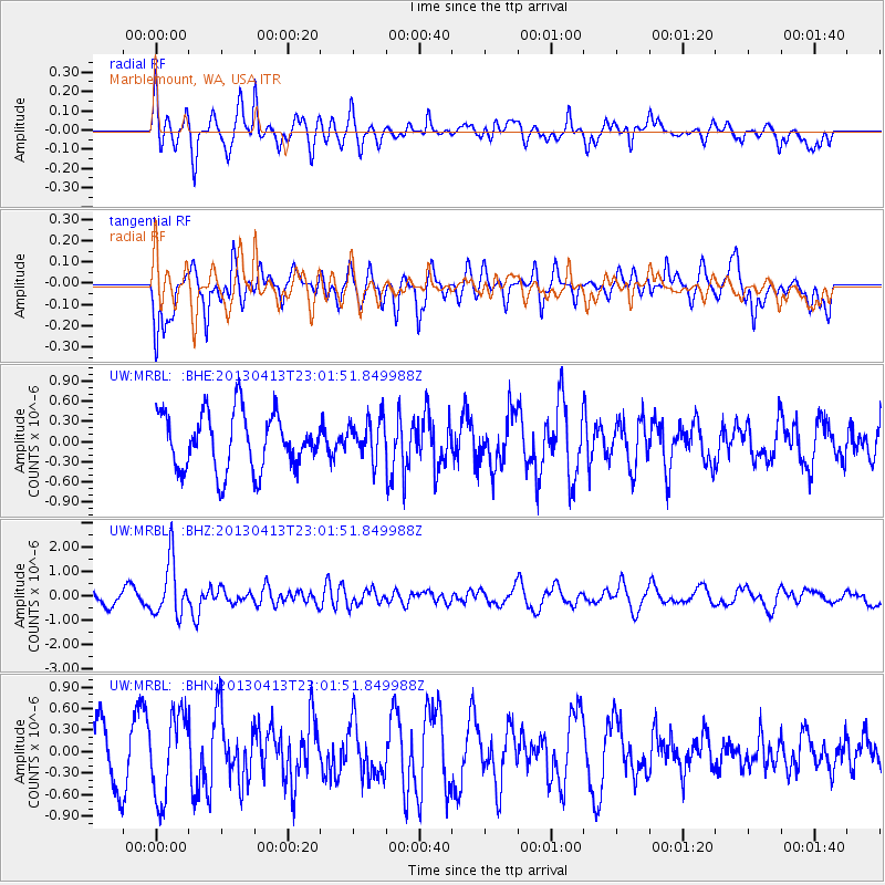
MRBL Marblemount, WA, USA - Earthquake Result Viewer
*The percent match for this event was below the threshold and hence no stack was calculated.
| Earthquake location: |
Vanuatu Islands |
| Earthquake latitude/longitude: |
-19.1/169.5 |
| Earthquake time(UTC): |
2013/04/13 (103) 22:49:50 GMT |
| Earthquake Depth: |
280 km |
| Earthquake Magnitude: |
6.0 MW, 5.9 MB, 6.0 MW |
| Earthquake Catalog/Contributor: |
NEIC PDE/NEIC PDE-W |
|
| Network: |
UW Pacific Northwest Regional Seismic Network |
| Station: |
MRBL Marblemount, WA, USA |
| Lat/Lon: |
48.52 N/121.48 W |
| Elevation: |
75 m |
|
| Distance: |
91.0 deg |
| Az: |
38.37 deg |
| Baz: |
241.961 deg |
| Ray Param: |
$rayparam |
*The percent match for this event was below the threshold and hence was not used in the summary stack. |
|
| Radial Match: |
56.467625 % |
| Radial Bump: |
400 |
| Transverse Match: |
68.965614 % |
| Transverse Bump: |
400 |
| SOD ConfigId: |
512894 |
| Insert Time: |
2013-09-13 06:23:27.602 +0000 |
| GWidth: |
2.5 |
| Max Bumps: |
400 |
| Tol: |
0.001 |
|
Signal To Noise
| Channel | StoN | STA | LTA |
| UW:MRBL: :BHZ:20130413T23:01:51.849988Z | 3.0255485 | 1.1449416E-6 | 3.784245E-7 |
| UW:MRBL: :BHN:20130413T23:01:51.849988Z | 2.0688953 | 5.898694E-7 | 2.8511317E-7 |
| UW:MRBL: :BHE:20130413T23:01:51.849988Z | 0.6974858 | 2.9196985E-7 | 4.186033E-7 |
| Arrivals |
| Ps | |
| PpPs | |
| PsPs/PpSs | |


