You are here: Home > Network List > AK - Alaska Regional Network Stations List
> Station ANM Anvil Mountian > Earthquake Result Viewer
ANM Anvil Mountian - Earthquake Result Viewer
| Earthquake location: |
Solomon Islands |
| Earthquake latitude/longitude: |
-6.5/154.6 |
| Earthquake time(UTC): |
2013/04/14 (104) 01:32:22 GMT |
| Earthquake Depth: |
31 km |
| Earthquake Magnitude: |
6.5 MW, 6.0 MB, 6.5 MS, 6.6 MW |
| Earthquake Catalog/Contributor: |
NEIC PDE/NEIC PDE-W |
|
| Network: |
AK Alaska Regional Network |
| Station: |
ANM Anvil Mountian |
| Lat/Lon: |
64.56 N/165.37 W |
| Elevation: |
330 m |
|
| Distance: |
76.8 deg |
| Az: |
16.574 deg |
| Baz: |
221.017 deg |
| Ray Param: |
0.050680988 |
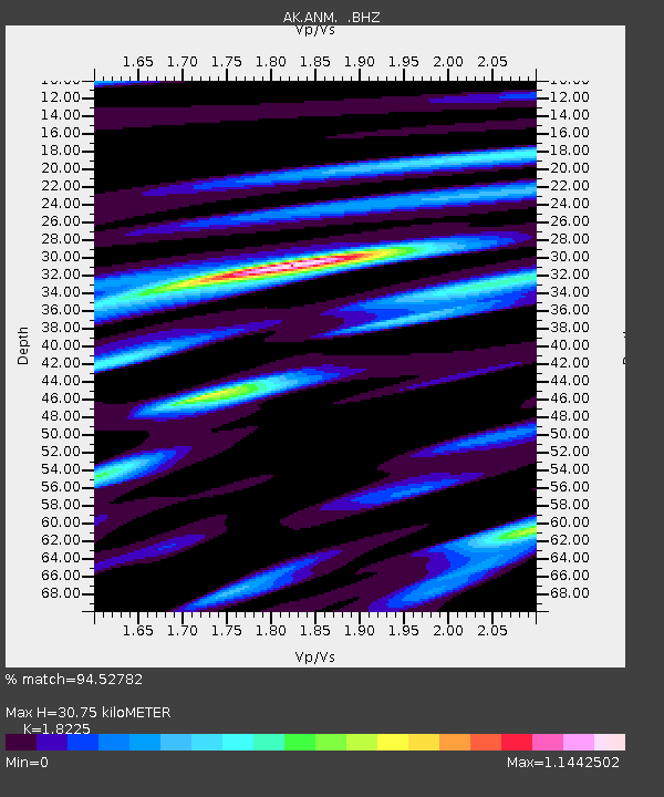
| Estimated Moho Depth: |
30.75 km |
| Estimated Crust Vp/Vs: |
1.82 |
| Assumed Crust Vp: |
6.276 km/s |
| Estimated Crust Vs: |
3.444 km/s |
| Estimated Crust Poisson's Ratio: |
0.28 |
|
| Radial Match: |
94.52782 % |
| Radial Bump: |
400 |
| Transverse Match: |
87.6491 % |
| Transverse Bump: |
400 |
| SOD ConfigId: |
512894 |
| Insert Time: |
2013-09-13 06:25:46.598 +0000 |
| GWidth: |
2.5 |
| Max Bumps: |
400 |
| Tol: |
0.001 |
|

Signal To Noise
| Channel | StoN | STA | LTA |
| AK:ANM: :BHZ:20130414T01:43:40.408005Z | 25.101357 | 2.414717E-6 | 9.619867E-8 |
| AK:ANM: :BHN:20130414T01:43:40.408005Z | 9.387068 | 7.6933674E-7 | 8.195709E-8 |
| AK:ANM: :BHE:20130414T01:43:40.408005Z | 8.4598255 | 4.5271125E-7 | 5.3513073E-8 |
| Arrivals |
| Ps | 4.1 SECOND |
| PpPs | 13 SECOND |
| PsPs/PpSs | 18 SECOND |


