You are here: Home > Network List > TA - USArray Transportable Network (new EarthScope stations) Stations List
> Station J01E Myrtle Point, OR, USA > Earthquake Result Viewer
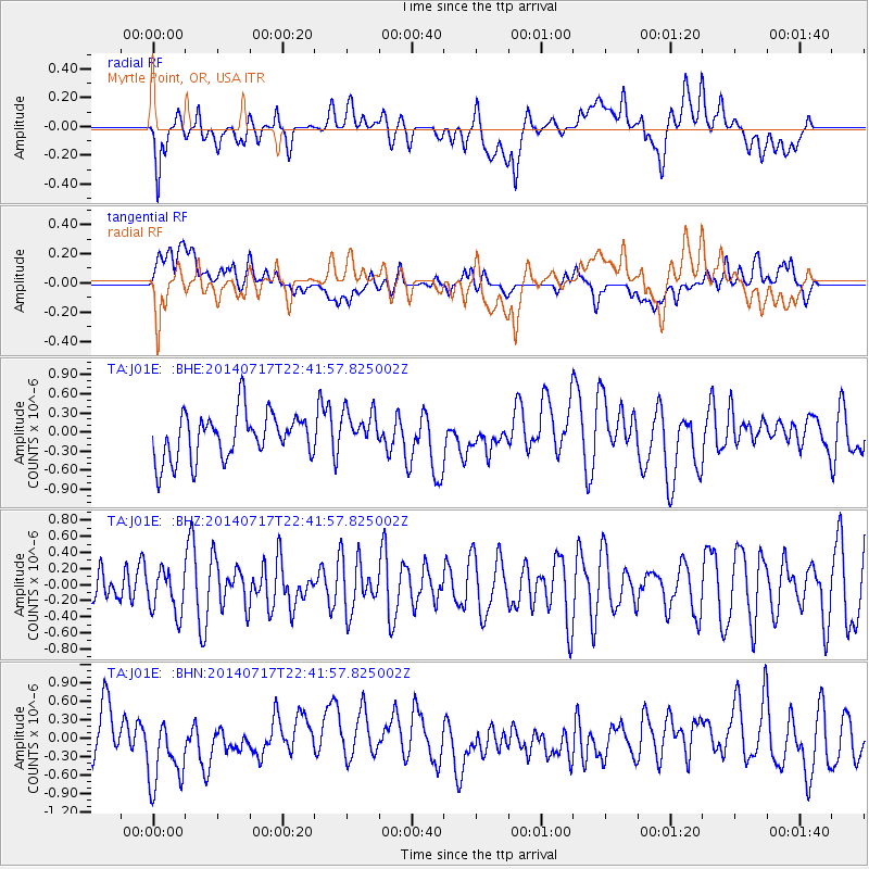
J01E Myrtle Point, OR, USA - Earthquake Result Viewer
*The percent match for this event was below the threshold and hence no stack was calculated.
| Earthquake location: |
Kuril Islands |
| Earthquake latitude/longitude: |
46.1/150.7 |
| Earthquake time(UTC): |
2014/07/17 (198) 22:32:46 GMT |
| Earthquake Depth: |
100 km |
| Earthquake Magnitude: |
5.1 MW, 4.9 mb |
| Earthquake Catalog/Contributor: |
ISC/ISC |
|
| Network: |
TA USArray Transportable Network (new EarthScope stations) |
| Station: |
J01E Myrtle Point, OR, USA |
| Lat/Lon: |
43.16 N/123.93 W |
| Elevation: |
128 m |
|
| Distance: |
57.9 deg |
| Az: |
59.395 deg |
| Baz: |
305.099 deg |
| Ray Param: |
$rayparam |
*The percent match for this event was below the threshold and hence was not used in the summary stack. |
|
| Radial Match: |
50.26742 % |
| Radial Bump: |
400 |
| Transverse Match: |
32.014496 % |
| Transverse Bump: |
400 |
| SOD ConfigId: |
3390531 |
| Insert Time: |
2019-04-12 22:20:07.510 +0000 |
| GWidth: |
2.5 |
| Max Bumps: |
400 |
| Tol: |
0.001 |
|
Signal To Noise
| Channel | StoN | STA | LTA |
| TA:J01E: :BHZ:20140717T22:41:57.825002Z | 0.67694265 | 2.6872976E-7 | 3.9697568E-7 |
| TA:J01E: :BHN:20140717T22:41:57.825002Z | 1.6222105 | 6.067029E-7 | 3.7399764E-7 |
| TA:J01E: :BHE:20140717T22:41:57.825002Z | 0.8180304 | 2.9906613E-7 | 3.655929E-7 |
| Arrivals |
| Ps | |
| PpPs | |
| PsPs/PpSs | |


