You are here: Home > Network List > TA - USArray Transportable Network (new EarthScope stations) Stations List
> Station O48A Farmland, IN, USA > Earthquake Result Viewer
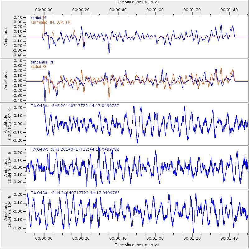
O48A Farmland, IN, USA - Earthquake Result Viewer
*The percent match for this event was below the threshold and hence no stack was calculated.
| Earthquake location: |
Kuril Islands |
| Earthquake latitude/longitude: |
46.1/150.7 |
| Earthquake time(UTC): |
2014/07/17 (198) 22:32:46 GMT |
| Earthquake Depth: |
100 km |
| Earthquake Magnitude: |
5.1 MW, 4.9 mb |
| Earthquake Catalog/Contributor: |
ISC/ISC |
|
| Network: |
TA USArray Transportable Network (new EarthScope stations) |
| Station: |
O48A Farmland, IN, USA |
| Lat/Lon: |
40.26 N/85.16 W |
| Elevation: |
300 m |
|
| Distance: |
80.6 deg |
| Az: |
39.961 deg |
| Baz: |
324.286 deg |
| Ray Param: |
$rayparam |
*The percent match for this event was below the threshold and hence was not used in the summary stack. |
|
| Radial Match: |
46.0363 % |
| Radial Bump: |
400 |
| Transverse Match: |
48.189045 % |
| Transverse Bump: |
400 |
| SOD ConfigId: |
3390531 |
| Insert Time: |
2019-04-12 22:20:24.360 +0000 |
| GWidth: |
2.5 |
| Max Bumps: |
400 |
| Tol: |
0.001 |
|
Signal To Noise
| Channel | StoN | STA | LTA |
| TA:O48A: :BHZ:20140717T22:44:17.049978Z | 1.0695043 | 8.0328974E-8 | 7.510861E-8 |
| TA:O48A: :BHN:20140717T22:44:17.049978Z | 0.9624437 | 1.1440107E-7 | 1.1886521E-7 |
| TA:O48A: :BHE:20140717T22:44:17.049978Z | 1.2284534 | 7.688916E-8 | 6.259021E-8 |
| Arrivals |
| Ps | |
| PpPs | |
| PsPs/PpSs | |


