You are here: Home > Network List > AK - Alaska Regional Network Stations List
> Station SSN Susitna > Earthquake Result Viewer
SSN Susitna - Earthquake Result Viewer
| Earthquake location: |
Solomon Islands |
| Earthquake latitude/longitude: |
-6.5/154.6 |
| Earthquake time(UTC): |
2013/04/14 (104) 01:32:22 GMT |
| Earthquake Depth: |
31 km |
| Earthquake Magnitude: |
6.5 MW, 6.0 MB, 6.5 MS, 6.6 MW |
| Earthquake Catalog/Contributor: |
NEIC PDE/NEIC PDE-W |
|
| Network: |
AK Alaska Regional Network |
| Station: |
SSN Susitna |
| Lat/Lon: |
61.46 N/150.74 W |
| Elevation: |
1293 m |
|
| Distance: |
79.8 deg |
| Az: |
23.453 deg |
| Baz: |
235.448 deg |
| Ray Param: |
0.048701014 |
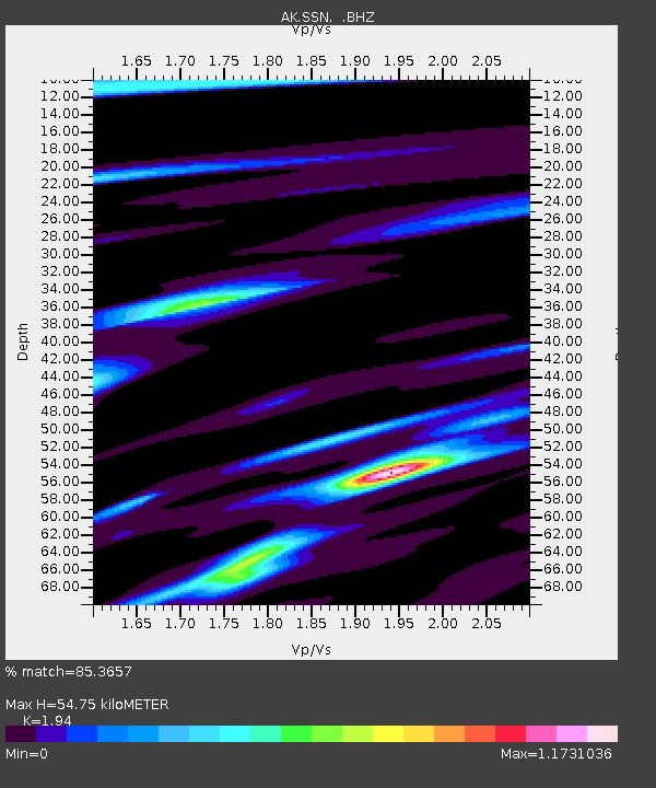
| Estimated Moho Depth: |
54.75 km |
| Estimated Crust Vp/Vs: |
1.94 |
| Assumed Crust Vp: |
6.302 km/s |
| Estimated Crust Vs: |
3.248 km/s |
| Estimated Crust Poisson's Ratio: |
0.32 |
|
| Radial Match: |
85.3657 % |
| Radial Bump: |
335 |
| Transverse Match: |
77.133644 % |
| Transverse Bump: |
357 |
| SOD ConfigId: |
512894 |
| Insert Time: |
2013-09-13 06:28:31.324 +0000 |
| GWidth: |
2.5 |
| Max Bumps: |
400 |
| Tol: |
0.001 |
|

Signal To Noise
| Channel | StoN | STA | LTA |
| AK:SSN: :BHZ:20130414T01:43:56.468003Z | 16.197983 | 2.4198896E-6 | 1.4939451E-7 |
| AK:SSN: :BHN:20130414T01:43:56.468003Z | 3.4849908 | 8.754451E-7 | 2.5120443E-7 |
| AK:SSN: :BHE:20130414T01:43:56.468003Z | 2.5056438 | 8.2901215E-7 | 3.3085794E-7 |
| Arrivals |
| Ps | 8.4 SECOND |
| PpPs | 25 SECOND |
| PsPs/PpSs | 33 SECOND |


