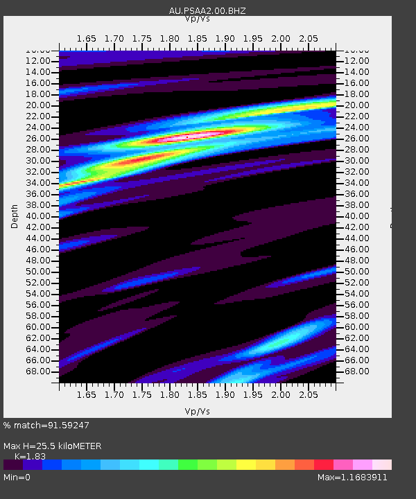
PSAA2 Pilbara Seismic Array Element A2 - Earthquake Result Viewer

Earthquake location: Solomon Islands
Earthquake latitude/longitude: -6.5/154.6
Earthquake time(UTC): 2013/04/14 (104) 01:32:22 GMT
Earthquake Depth: 31 km
Earthquake Magnitude: 6.5 MW, 6.0 MB, 6.5 MS, 6.6 MW
Earthquake Catalog/Contributor: NEIC PDE/NEIC PDE-W
Network: AU Australian Seismological Centre
Station: PSAA2 Pilbara Seismic Array Element A2
Lat/Lon: 21.56 S/119.85 E
Elevation: 330 m
Distance: 36.8 deg
Az: 242.403 deg
Baz: 71.096 deg
Ray Param: 0.076434486
Estimated Moho Depth: 25.5 km
Estimated Crust Vp/Vs: 1.83
Assumed Crust Vp: 6.464 km/s
Estimated Crust Vs: 3.532 km/s
Estimated Crust Poisson's Ratio: 0.29
Radial Match: 91.59247 %
Radial Bump: 206
Transverse Match: 63.30787 %
Transverse Bump: 400
SOD ConfigId: 512894
Insert Time: 2013-09-13 06:30:06.792 +0000
GWidth: 2.5
Max Bumps: 400
Tol: 0.001

Signal To Noise

ChannelStoNSTALTA
AU:PSAA2:00:BHZ:20130414T01:38:57.043992Z8.165871.8095996E-62.2160523E-7
AU:PSAA2:00:BH1:20130414T01:38:57.043992Z5.76179039.0605664E-71.5725263E-7
AU:PSAA2:00:BH2:20130414T01:38:57.043992Z2.05790543.565351E-71.7325145E-7
Arrivals
Ps3.5 SECOND
PpPs10 SECOND
PsPs/PpSs14 SECOND