You are here: Home > Network List > CB - China National Seismic Network Stations List
> Station GOM Geermu,Qinghai Province > Earthquake Result Viewer
GOM Geermu,Qinghai Province - Earthquake Result Viewer
| Earthquake location: |
Solomon Islands |
| Earthquake latitude/longitude: |
-6.5/154.6 |
| Earthquake time(UTC): |
2013/04/14 (104) 01:32:22 GMT |
| Earthquake Depth: |
31 km |
| Earthquake Magnitude: |
6.5 MW, 6.0 MB, 6.5 MS, 6.6 MW |
| Earthquake Catalog/Contributor: |
NEIC PDE/NEIC PDE-W |
|
| Network: |
CB China National Seismic Network |
| Station: |
GOM Geermu,Qinghai Province |
| Lat/Lon: |
36.20 N/94.81 E |
| Elevation: |
3121 m |
|
| Distance: |
70.2 deg |
| Az: |
312.022 deg |
| Baz: |
114.125 deg |
| Ray Param: |
0.055086963 |
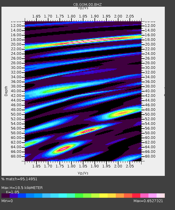
| Estimated Moho Depth: |
18.5 km |
| Estimated Crust Vp/Vs: |
1.85 |
| Assumed Crust Vp: |
6.385 km/s |
| Estimated Crust Vs: |
3.451 km/s |
| Estimated Crust Poisson's Ratio: |
0.29 |
|
| Radial Match: |
95.14951 % |
| Radial Bump: |
400 |
| Transverse Match: |
84.53423 % |
| Transverse Bump: |
400 |
| SOD ConfigId: |
512894 |
| Insert Time: |
2013-09-13 06:32:44.389 +0000 |
| GWidth: |
2.5 |
| Max Bumps: |
400 |
| Tol: |
0.001 |
|

Signal To Noise
| Channel | StoN | STA | LTA |
| CB:GOM:00:BHZ:20130414T01:43:01.540024Z | 18.59315 | 2.4029257E-6 | 1.2923716E-7 |
| CB:GOM:00:BHN:20130414T01:43:01.540024Z | 9.495676 | 3.2646628E-7 | 3.438052E-8 |
| CB:GOM:00:BHE:20130414T01:43:01.540024Z | 17.115429 | 5.9584687E-7 | 3.4813436E-8 |
| Arrivals |
| Ps | 2.6 SECOND |
| PpPs | 8.0 SECOND |
| PsPs/PpSs | 11 SECOND |


