You are here: Home > Network List > CB - China National Seismic Network Stations List
> Station HHC Huhehaote,Neimeng Province > Earthquake Result Viewer
HHC Huhehaote,Neimeng Province - Earthquake Result Viewer
| Earthquake location: |
Solomon Islands |
| Earthquake latitude/longitude: |
-6.5/154.6 |
| Earthquake time(UTC): |
2013/04/14 (104) 01:32:22 GMT |
| Earthquake Depth: |
31 km |
| Earthquake Magnitude: |
6.5 MW, 6.0 MB, 6.5 MS, 6.6 MW |
| Earthquake Catalog/Contributor: |
NEIC PDE/NEIC PDE-W |
|
| Network: |
CB China National Seismic Network |
| Station: |
HHC Huhehaote,Neimeng Province |
| Lat/Lon: |
40.85 N/111.56 E |
| Elevation: |
1169 m |
|
| Distance: |
61.4 deg |
| Az: |
323.882 deg |
| Baz: |
129.453 deg |
| Ray Param: |
0.060816906 |
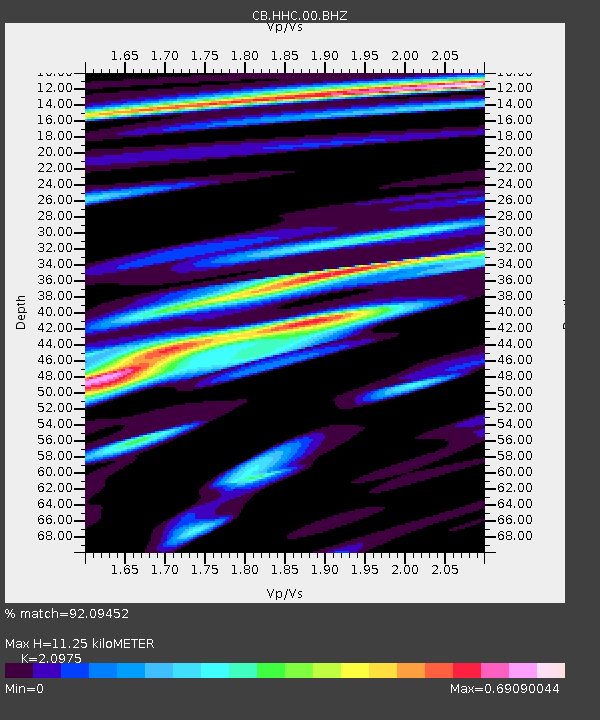
| Estimated Moho Depth: |
11.25 km |
| Estimated Crust Vp/Vs: |
2.10 |
| Assumed Crust Vp: |
6.384 km/s |
| Estimated Crust Vs: |
3.044 km/s |
| Estimated Crust Poisson's Ratio: |
0.35 |
|
| Radial Match: |
92.09452 % |
| Radial Bump: |
400 |
| Transverse Match: |
77.46681 % |
| Transverse Bump: |
400 |
| SOD ConfigId: |
512894 |
| Insert Time: |
2013-09-13 06:32:56.444 +0000 |
| GWidth: |
2.5 |
| Max Bumps: |
400 |
| Tol: |
0.001 |
|

Signal To Noise
| Channel | StoN | STA | LTA |
| CB:HHC:00:BHZ:20130414T01:42:05.270005Z | 12.121768 | 2.4097517E-6 | 1.9879539E-7 |
| CB:HHC:00:BHN:20130414T01:42:05.270005Z | 4.197525 | 8.2031244E-7 | 1.9542763E-7 |
| CB:HHC:00:BHE:20130414T01:42:05.270005Z | 3.9209251 | 7.928148E-7 | 2.0220095E-7 |
| Arrivals |
| Ps | 2.0 SECOND |
| PpPs | 5.3 SECOND |
| PsPs/PpSs | 7.3 SECOND |


