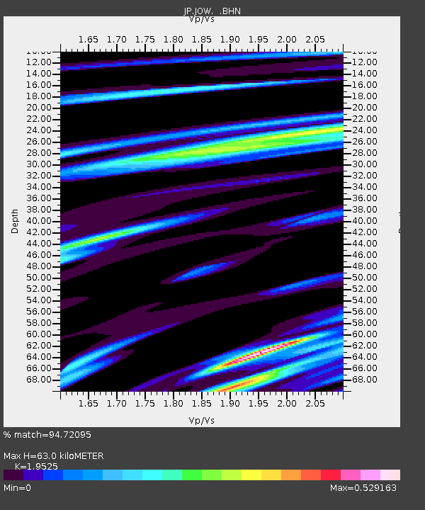
JOW Okinawa Kunigami - Earthquake Result Viewer

Earthquake location: Solomon Islands
Earthquake latitude/longitude: -6.5/154.6
Earthquake time(UTC): 2013/04/14 (104) 01:32:22 GMT
Earthquake Depth: 31 km
Earthquake Magnitude: 6.5 MW, 6.0 MB, 6.5 MS, 6.6 MW
Earthquake Catalog/Contributor: NEIC PDE/NEIC PDE-W
Network: JP Japan Meteorological Agency Seismic Network
Station: JOW Okinawa Kunigami
Lat/Lon: 26.84 N/128.27 E
Elevation: 220 m
Distance: 41.8 deg
Az: 323.512 deg
Baz: 138.599 deg
Ray Param: 0.07349879
Estimated Moho Depth: 63.0 km
Estimated Crust Vp/Vs: 1.95
Assumed Crust Vp: 6.183 km/s
Estimated Crust Vs: 3.167 km/s
Estimated Crust Poisson's Ratio: 0.32
Radial Match: 94.72095 %
Radial Bump: 206
Transverse Match: 76.42744 %
Transverse Bump: 400
SOD ConfigId: 512894
Insert Time: 2013-09-13 06:39:46.338 +0000
GWidth: 2.5
Max Bumps: 400
Tol: 0.001

Signal To Noise

ChannelStoNSTALTA
JP:JOW: :BHZ:20130414T01:39:38.849991Z11.3781331.7072351E-61.5004528E-7
JP:JOW: :BHN:20130414T01:39:38.849991Z12.5666911.521092E-61.2104158E-7
JP:JOW: :BHE:20130414T01:39:38.849991Z11.7946141.1548393E-69.7912434E-8
Arrivals
Ps10 SECOND
PpPs28 SECOND
PsPs/PpSs39 SECOND