You are here: Home > Network List > TA - USArray Transportable Network (new EarthScope stations) Stations List
> Station H17A Grant Village (NPS), Yellowstone Nt. Park, WY, USA > Earthquake Result Viewer
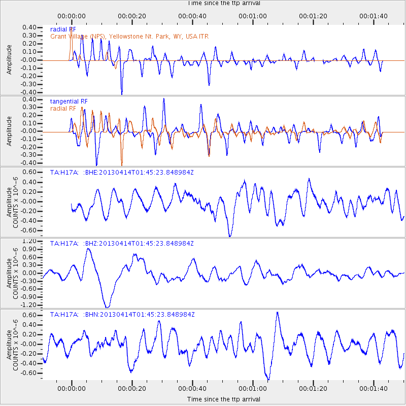
H17A Grant Village (NPS), Yellowstone Nt. Park, WY, USA - Earthquake Result Viewer
*The percent match for this event was below the threshold and hence no stack was calculated.
| Earthquake location: |
Solomon Islands |
| Earthquake latitude/longitude: |
-6.5/154.6 |
| Earthquake time(UTC): |
2013/04/14 (104) 01:32:22 GMT |
| Earthquake Depth: |
31 km |
| Earthquake Magnitude: |
6.5 MW, 6.0 MB, 6.5 MS, 6.6 MW |
| Earthquake Catalog/Contributor: |
NEIC PDE/NEIC PDE-W |
|
| Network: |
TA USArray Transportable Network (new EarthScope stations) |
| Station: |
H17A Grant Village (NPS), Yellowstone Nt. Park, WY, USA |
| Lat/Lon: |
44.40 N/110.58 W |
| Elevation: |
2400 m |
|
| Distance: |
97.9 deg |
| Az: |
46.157 deg |
| Baz: |
268.72 deg |
| Ray Param: |
$rayparam |
*The percent match for this event was below the threshold and hence was not used in the summary stack. |
|
| Radial Match: |
65.79917 % |
| Radial Bump: |
400 |
| Transverse Match: |
65.837234 % |
| Transverse Bump: |
400 |
| SOD ConfigId: |
512894 |
| Insert Time: |
2013-09-13 06:44:15.799 +0000 |
| GWidth: |
2.5 |
| Max Bumps: |
400 |
| Tol: |
0.001 |
|
Signal To Noise
| Channel | StoN | STA | LTA |
| TA:H17A: :BHZ:20130414T01:45:23.848984Z | 2.1133344 | 2.8666636E-7 | 1.3564647E-7 |
| TA:H17A: :BHN:20130414T01:45:23.848984Z | 0.66562104 | 1.6446042E-7 | 2.4707813E-7 |
| TA:H17A: :BHE:20130414T01:45:23.848984Z | 1.0830905 | 1.9932462E-7 | 1.840332E-7 |
| Arrivals |
| Ps | |
| PpPs | |
| PsPs/PpSs | |


