You are here: Home > Network List > TA - USArray Transportable Network (new EarthScope stations) Stations List
> Station O03E Paynes Creek, CA, USA > Earthquake Result Viewer
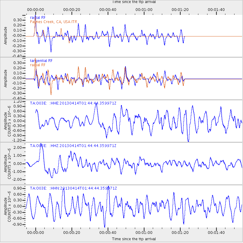
O03E Paynes Creek, CA, USA - Earthquake Result Viewer
*The percent match for this event was below the threshold and hence no stack was calculated.
| Earthquake location: |
Solomon Islands |
| Earthquake latitude/longitude: |
-6.5/154.6 |
| Earthquake time(UTC): |
2013/04/14 (104) 01:32:22 GMT |
| Earthquake Depth: |
31 km |
| Earthquake Magnitude: |
6.5 MW, 6.0 MB, 6.5 MS, 6.6 MW |
| Earthquake Catalog/Contributor: |
NEIC PDE/NEIC PDE-W |
|
| Network: |
TA USArray Transportable Network (new EarthScope stations) |
| Station: |
O03E Paynes Creek, CA, USA |
| Lat/Lon: |
40.29 N/121.80 W |
| Elevation: |
967 m |
|
| Distance: |
89.3 deg |
| Az: |
49.477 deg |
| Baz: |
260.958 deg |
| Ray Param: |
$rayparam |
*The percent match for this event was below the threshold and hence was not used in the summary stack. |
|
| Radial Match: |
66.667915 % |
| Radial Bump: |
362 |
| Transverse Match: |
56.18721 % |
| Transverse Bump: |
348 |
| SOD ConfigId: |
512894 |
| Insert Time: |
2013-09-13 06:45:13.089 +0000 |
| GWidth: |
2.5 |
| Max Bumps: |
400 |
| Tol: |
0.001 |
|
Signal To Noise
| Channel | StoN | STA | LTA |
| TA:O03E: :HHZ:20130414T01:44:44.359971Z | 9.248775 | 1.304237E-6 | 1.4101728E-7 |
| TA:O03E: :HHN:20130414T01:44:44.359971Z | 1.3450469 | 3.1483412E-7 | 2.3406926E-7 |
| TA:O03E: :HHE:20130414T01:44:44.359971Z | 1.9277567 | 5.3109426E-7 | 2.754986E-7 |
| Arrivals |
| Ps | |
| PpPs | |
| PsPs/PpSs | |


