You are here: Home > Network List > TA - USArray Transportable Network (new EarthScope stations) Stations List
> Station TPFO Pinon Flats, CA, USA > Earthquake Result Viewer
TPFO Pinon Flats, CA, USA - Earthquake Result Viewer
*The percent match for this event was below the threshold and hence no stack was calculated.
| Earthquake location: |
Solomon Islands |
| Earthquake latitude/longitude: |
-6.5/154.6 |
| Earthquake time(UTC): |
2013/04/14 (104) 01:32:22 GMT |
| Earthquake Depth: |
31 km |
| Earthquake Magnitude: |
6.5 MW, 6.0 MB, 6.5 MS, 6.6 MW |
| Earthquake Catalog/Contributor: |
NEIC PDE/NEIC PDE-W |
|
| Network: |
TA USArray Transportable Network (new EarthScope stations) |
| Station: |
TPFO Pinon Flats, CA, USA |
| Lat/Lon: |
33.61 N/116.45 W |
| Elevation: |
1275 m |
|
| Distance: |
92.7 deg |
| Az: |
56.65 deg |
| Baz: |
264.045 deg |
| Ray Param: |
$rayparam |
*The percent match for this event was below the threshold and hence was not used in the summary stack. |
|
| Radial Match: |
65.34042 % |
| Radial Bump: |
314 |
| Transverse Match: |
62.646507 % |
| Transverse Bump: |
400 |
| SOD ConfigId: |
512894 |
| Insert Time: |
2013-09-13 06:45:21.283 +0000 |
| GWidth: |
2.5 |
| Max Bumps: |
400 |
| Tol: |
0.001 |
|
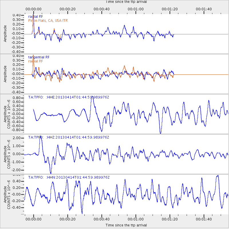
Signal To Noise
| Channel | StoN | STA | LTA |
| TA:TPFO: :HHZ:20130414T01:44:59.989976Z | 4.5467863 | 1.0193306E-6 | 2.2418705E-7 |
| TA:TPFO: :HHN:20130414T01:44:59.989976Z | 0.9088274 | 1.8816313E-7 | 2.0703946E-7 |
| TA:TPFO: :HHE:20130414T01:44:59.989976Z | 2.9185348 | 4.451899E-7 | 1.5253883E-7 |
| Arrivals |
| Ps | |
| PpPs | |
| PsPs/PpSs | |


