You are here: Home > Network List > US - United States National Seismic Network Stations List
> Station ELK Elko, Nevada, USA > Earthquake Result Viewer
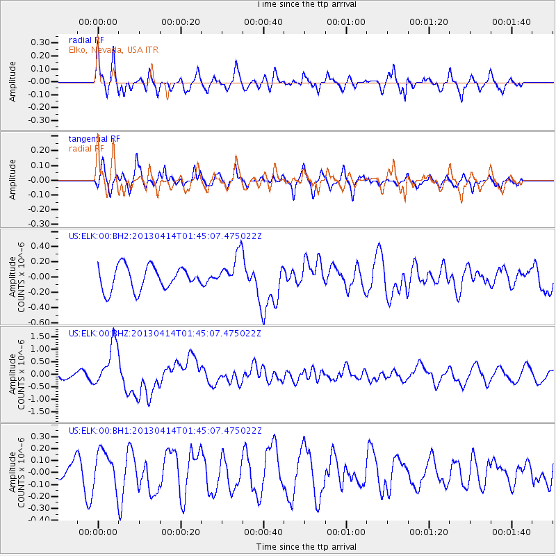
ELK Elko, Nevada, USA - Earthquake Result Viewer
*The percent match for this event was below the threshold and hence no stack was calculated.
| Earthquake location: |
Solomon Islands |
| Earthquake latitude/longitude: |
-6.5/154.6 |
| Earthquake time(UTC): |
2013/04/14 (104) 01:32:22 GMT |
| Earthquake Depth: |
31 km |
| Earthquake Magnitude: |
6.5 MW, 6.0 MB, 6.5 MS, 6.6 MW |
| Earthquake Catalog/Contributor: |
NEIC PDE/NEIC PDE-W |
|
| Network: |
US United States National Seismic Network |
| Station: |
ELK Elko, Nevada, USA |
| Lat/Lon: |
40.74 N/115.24 W |
| Elevation: |
2210 m |
|
| Distance: |
94.3 deg |
| Az: |
49.634 deg |
| Baz: |
265.204 deg |
| Ray Param: |
$rayparam |
*The percent match for this event was below the threshold and hence was not used in the summary stack. |
|
| Radial Match: |
69.75128 % |
| Radial Bump: |
400 |
| Transverse Match: |
53.558235 % |
| Transverse Bump: |
400 |
| SOD ConfigId: |
512894 |
| Insert Time: |
2013-09-13 06:46:14.010 +0000 |
| GWidth: |
2.5 |
| Max Bumps: |
400 |
| Tol: |
0.001 |
|
Signal To Noise
| Channel | StoN | STA | LTA |
| US:ELK:00:BHZ:20130414T01:45:07.475022Z | 6.9860396 | 9.121511E-7 | 1.305677E-7 |
| US:ELK:00:BH1:20130414T01:45:07.475022Z | 1.3079426 | 1.5370652E-7 | 1.17517786E-7 |
| US:ELK:00:BH2:20130414T01:45:07.475022Z | 1.5362663 | 2.3536745E-7 | 1.5320747E-7 |
| Arrivals |
| Ps | |
| PpPs | |
| PsPs/PpSs | |


