You are here: Home > Network List > UU - University of Utah Regional Network Stations List
> Station ASI2 Darling Creek, Challis, ID, USA > Earthquake Result Viewer
ASI2 Darling Creek, Challis, ID, USA - Earthquake Result Viewer
| Earthquake location: |
Near Coast Of Northern Chile |
| Earthquake latitude/longitude: |
-20.2/-70.9 |
| Earthquake time(UTC): |
2014/07/18 (199) 05:24:10 GMT |
| Earthquake Depth: |
15 km |
| Earthquake Magnitude: |
5.0 MW, 4.7 ML, 5.0 Mww, 4.9 Mwr, 4.8 mb |
| Earthquake Catalog/Contributor: |
ISC/ISC |
|
| Network: |
UU University of Utah Regional Network |
| Station: |
ASI2 Darling Creek, Challis, ID, USA |
| Lat/Lon: |
44.57 N/114.26 W |
| Elevation: |
1600 m |
|
| Distance: |
75.6 deg |
| Az: |
329.547 deg |
| Baz: |
138.221 deg |
| Ray Param: |
0.051539473 |
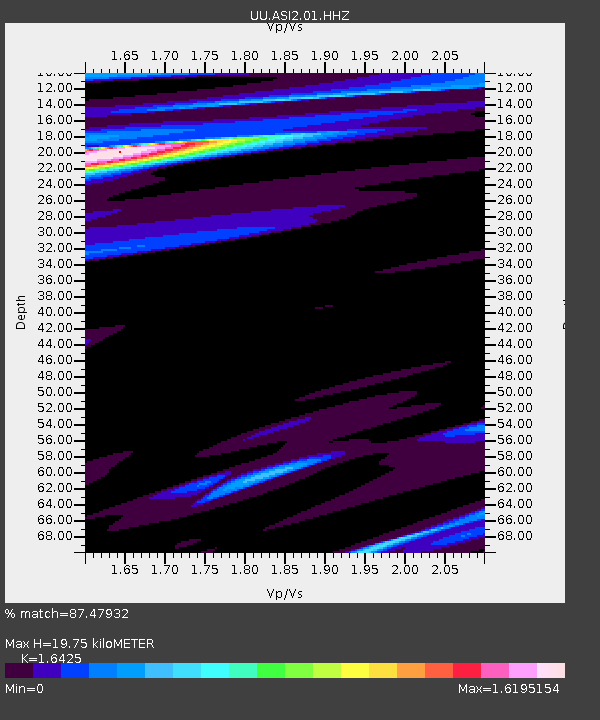
| Estimated Moho Depth: |
19.75 km |
| Estimated Crust Vp/Vs: |
1.64 |
| Assumed Crust Vp: |
6.577 km/s |
| Estimated Crust Vs: |
4.004 km/s |
| Estimated Crust Poisson's Ratio: |
0.21 |
|
| Radial Match: |
87.47932 % |
| Radial Bump: |
298 |
| Transverse Match: |
83.89471 % |
| Transverse Bump: |
338 |
| SOD ConfigId: |
3390531 |
| Insert Time: |
2019-04-12 22:29:43.274 +0000 |
| GWidth: |
2.5 |
| Max Bumps: |
400 |
| Tol: |
0.001 |
|

Signal To Noise
| Channel | StoN | STA | LTA |
| UU:ASI2:01:HHZ:20140718T05:35:23.29801Z | 2.8063624 | 3.393534E-8 | 1.2092287E-8 |
| UU:ASI2:01:HHN:20140718T05:35:23.29801Z | 0.77624357 | 9.624333E-9 | 1.23985995E-8 |
| UU:ASI2:01:HHE:20140718T05:35:23.29801Z | 1.4793336 | 6.2578835E-8 | 4.2302045E-8 |
| Arrivals |
| Ps | 2.0 SECOND |
| PpPs | 7.7 SECOND |
| PsPs/PpSs | 9.7 SECOND |


