You are here: Home > Network List > AK - Alaska Regional Network Stations List
> Station CAST Castle Rocks > Earthquake Result Viewer
CAST Castle Rocks - Earthquake Result Viewer
| Earthquake location: |
Southern Iran |
| Earthquake latitude/longitude: |
28.0/62.0 |
| Earthquake time(UTC): |
2013/04/16 (106) 10:44:20 GMT |
| Earthquake Depth: |
80 km |
| Earthquake Magnitude: |
7.7 MW, 7.0 MB, 7.7 MW |
| Earthquake Catalog/Contributor: |
NEIC PDE/NEIC PDE-W |
|
| Network: |
AK Alaska Regional Network |
| Station: |
CAST Castle Rocks |
| Lat/Lon: |
63.42 N/152.08 W |
| Elevation: |
611 m |
|
| Distance: |
84.9 deg |
| Az: |
14.658 deg |
| Baz: |
330.182 deg |
| Ray Param: |
0.044958193 |
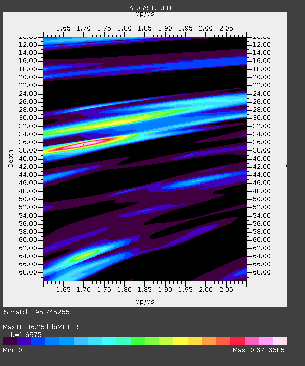
| Estimated Moho Depth: |
36.25 km |
| Estimated Crust Vp/Vs: |
1.70 |
| Assumed Crust Vp: |
6.566 km/s |
| Estimated Crust Vs: |
3.868 km/s |
| Estimated Crust Poisson's Ratio: |
0.23 |
|
| Radial Match: |
95.745255 % |
| Radial Bump: |
333 |
| Transverse Match: |
94.428604 % |
| Transverse Bump: |
391 |
| SOD ConfigId: |
512894 |
| Insert Time: |
2013-09-13 07:11:14.094 +0000 |
| GWidth: |
2.5 |
| Max Bumps: |
400 |
| Tol: |
0.001 |
|

Signal To Noise
| Channel | StoN | STA | LTA |
| AK:CAST: :BHZ:20130416T10:56:15.34803Z | 14.621285 | 2.7850158E-6 | 1.9047681E-7 |
| AK:CAST: :BHN:20130416T10:56:15.34803Z | 4.340077 | 6.500732E-7 | 1.497838E-7 |
| AK:CAST: :BHE:20130416T10:56:15.34803Z | 2.49689 | 6.7768127E-7 | 2.7141016E-7 |
| Arrivals |
| Ps | 4.0 SECOND |
| PpPs | 15 SECOND |
| PsPs/PpSs | 18 SECOND |


