You are here: Home > Network List > AK - Alaska Regional Network Stations List
> Station KLU Klutina Pass, AK, USA > Earthquake Result Viewer
KLU Klutina Pass, AK, USA - Earthquake Result Viewer
| Earthquake location: |
Southern Iran |
| Earthquake latitude/longitude: |
28.0/62.0 |
| Earthquake time(UTC): |
2013/04/16 (106) 10:44:20 GMT |
| Earthquake Depth: |
80 km |
| Earthquake Magnitude: |
7.7 MW, 7.0 MB, 7.7 MW |
| Earthquake Catalog/Contributor: |
NEIC PDE/NEIC PDE-W |
|
| Network: |
AK Alaska Regional Network |
| Station: |
KLU Klutina Pass, AK, USA |
| Lat/Lon: |
61.49 N/145.92 W |
| Elevation: |
1047 m |
|
| Distance: |
88.0 deg |
| Az: |
12.989 deg |
| Baz: |
335.534 deg |
| Ray Param: |
0.042777736 |
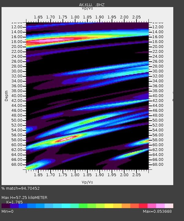
| Estimated Moho Depth: |
57.25 km |
| Estimated Crust Vp/Vs: |
1.76 |
| Assumed Crust Vp: |
6.566 km/s |
| Estimated Crust Vs: |
3.72 km/s |
| Estimated Crust Poisson's Ratio: |
0.26 |
|
| Radial Match: |
94.70452 % |
| Radial Bump: |
400 |
| Transverse Match: |
85.98222 % |
| Transverse Bump: |
400 |
| SOD ConfigId: |
512894 |
| Insert Time: |
2013-09-13 07:12:21.609 +0000 |
| GWidth: |
2.5 |
| Max Bumps: |
400 |
| Tol: |
0.001 |
|

Signal To Noise
| Channel | StoN | STA | LTA |
| AK:KLU: :BHZ:20130416T10:56:30.08802Z | 8.5013075 | 1.0841362E-6 | 1.2752584E-7 |
| AK:KLU: :BHN:20130416T10:56:30.08802Z | 1.9205366 | 3.1889073E-7 | 1.6604251E-7 |
| AK:KLU: :BHE:20130416T10:56:30.08802Z | 1.9063871 | 2.2424221E-7 | 1.176268E-7 |
| Arrivals |
| Ps | 6.8 SECOND |
| PpPs | 24 SECOND |
| PsPs/PpSs | 30 SECOND |


