You are here: Home > Network List > AK - Alaska Regional Network Stations List
> Station PPD Porcupine Dome, AK, USA > Earthquake Result Viewer
PPD Porcupine Dome, AK, USA - Earthquake Result Viewer
| Earthquake location: |
Southern Iran |
| Earthquake latitude/longitude: |
28.0/62.0 |
| Earthquake time(UTC): |
2013/04/16 (106) 10:44:20 GMT |
| Earthquake Depth: |
80 km |
| Earthquake Magnitude: |
7.7 MW, 7.0 MB, 7.7 MW |
| Earthquake Catalog/Contributor: |
NEIC PDE/NEIC PDE-W |
|
| Network: |
AK Alaska Regional Network |
| Station: |
PPD Porcupine Dome, AK, USA |
| Lat/Lon: |
65.52 N/145.52 W |
| Elevation: |
1498 m |
|
| Distance: |
84.4 deg |
| Az: |
11.155 deg |
| Baz: |
335.772 deg |
| Ray Param: |
0.04537453 |
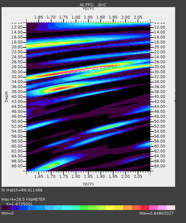
| Estimated Moho Depth: |
28.5 km |
| Estimated Crust Vp/Vs: |
1.87 |
| Assumed Crust Vp: |
6.566 km/s |
| Estimated Crust Vs: |
3.507 km/s |
| Estimated Crust Poisson's Ratio: |
0.30 |
|
| Radial Match: |
96.611496 % |
| Radial Bump: |
375 |
| Transverse Match: |
89.533875 % |
| Transverse Bump: |
400 |
| SOD ConfigId: |
512894 |
| Insert Time: |
2013-09-13 07:13:00.064 +0000 |
| GWidth: |
2.5 |
| Max Bumps: |
400 |
| Tol: |
0.001 |
|

Signal To Noise
| Channel | StoN | STA | LTA |
| AK:PPD: :BHZ:20130416T10:56:12.408027Z | 6.6376314 | 1.0999319E-6 | 1.6571151E-7 |
| AK:PPD: :BHN:20130416T10:56:12.408027Z | 3.282358 | 5.726792E-7 | 1.744719E-7 |
| AK:PPD: :BHE:20130416T10:56:12.408027Z | 1.0367979 | 2.3230083E-7 | 2.2405604E-7 |
| Arrivals |
| Ps | 3.9 SECOND |
| PpPs | 12 SECOND |
| PsPs/PpSs | 16 SECOND |


