You are here: Home > Network List > AK - Alaska Regional Network Stations List
> Station TRF Thorofare Mountian > Earthquake Result Viewer
TRF Thorofare Mountian - Earthquake Result Viewer
| Earthquake location: |
Southern Iran |
| Earthquake latitude/longitude: |
28.0/62.0 |
| Earthquake time(UTC): |
2013/04/16 (106) 10:44:20 GMT |
| Earthquake Depth: |
80 km |
| Earthquake Magnitude: |
7.7 MW, 7.0 MB, 7.7 MW |
| Earthquake Catalog/Contributor: |
NEIC PDE/NEIC PDE-W |
|
| Network: |
AK Alaska Regional Network |
| Station: |
TRF Thorofare Mountian |
| Lat/Lon: |
63.45 N/150.29 W |
| Elevation: |
1717 m |
|
| Distance: |
85.3 deg |
| Az: |
13.935 deg |
| Baz: |
331.724 deg |
| Ray Param: |
0.04469782 |
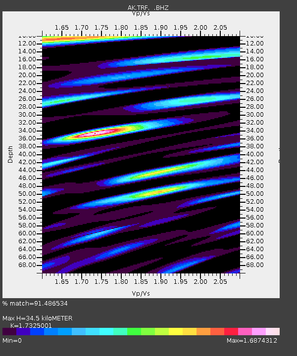
| Estimated Moho Depth: |
34.5 km |
| Estimated Crust Vp/Vs: |
1.73 |
| Assumed Crust Vp: |
6.438 km/s |
| Estimated Crust Vs: |
3.716 km/s |
| Estimated Crust Poisson's Ratio: |
0.25 |
|
| Radial Match: |
91.486534 % |
| Radial Bump: |
400 |
| Transverse Match: |
84.52229 % |
| Transverse Bump: |
400 |
| SOD ConfigId: |
512894 |
| Insert Time: |
2013-09-13 07:13:54.402 +0000 |
| GWidth: |
2.5 |
| Max Bumps: |
400 |
| Tol: |
0.001 |
|

Signal To Noise
| Channel | StoN | STA | LTA |
| AK:TRF: :BHZ:20130416T10:56:17.140022Z | 6.6244483 | 1.2368378E-6 | 1.8670804E-7 |
| AK:TRF: :BHN:20130416T10:56:17.140022Z | 2.2135706 | 4.44716E-7 | 2.0090437E-7 |
| AK:TRF: :BHE:20130416T10:56:17.140022Z | 1.2454703 | 2.59816E-7 | 2.0860877E-7 |
| Arrivals |
| Ps | 4.0 SECOND |
| PpPs | 14 SECOND |
| PsPs/PpSs | 18 SECOND |


