You are here: Home > Network List > TA - USArray Transportable Network (new EarthScope stations) Stations List
> Station G65A Princeton, ME, USA > Earthquake Result Viewer
G65A Princeton, ME, USA - Earthquake Result Viewer
*The percent match for this event was below the threshold and hence no stack was calculated.
| Earthquake location: |
Kuril Islands |
| Earthquake latitude/longitude: |
46.6/152.6 |
| Earthquake time(UTC): |
2014/07/18 (199) 18:13:49 GMT |
| Earthquake Depth: |
0.0 km |
| Earthquake Magnitude: |
4.7 mb, 3.8 ML, 3.6 mbtmp, 3.4 mb1mx, 3.7 mb1, 3.6 mb |
| Earthquake Catalog/Contributor: |
ISC/ISC |
|
| Network: |
TA USArray Transportable Network (new EarthScope stations) |
| Station: |
G65A Princeton, ME, USA |
| Lat/Lon: |
45.20 N/67.56 W |
| Elevation: |
78 m |
|
| Distance: |
82.0 deg |
| Az: |
27.408 deg |
| Baz: |
333.339 deg |
| Ray Param: |
$rayparam |
*The percent match for this event was below the threshold and hence was not used in the summary stack. |
|
| Radial Match: |
18.718864 % |
| Radial Bump: |
400 |
| Transverse Match: |
11.309953 % |
| Transverse Bump: |
400 |
| SOD ConfigId: |
3390531 |
| Insert Time: |
2019-04-12 22:37:45.585 +0000 |
| GWidth: |
2.5 |
| Max Bumps: |
400 |
| Tol: |
0.001 |
|
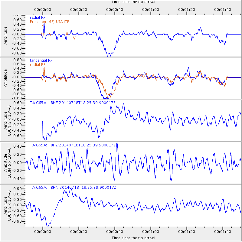
Signal To Noise
| Channel | StoN | STA | LTA |
| TA:G65A: :BHZ:20140718T18:25:39.900017Z | 1.1375378 | 1.4934993E-7 | 1.3129228E-7 |
| TA:G65A: :BHN:20140718T18:25:39.900017Z | 1.2924898 | 5.685023E-7 | 4.398505E-7 |
| TA:G65A: :BHE:20140718T18:25:39.900017Z | 0.95734614 | 2.3492814E-7 | 2.453952E-7 |
| Arrivals |
| Ps | |
| PpPs | |
| PsPs/PpSs | |


