You are here: Home > Network List > EI - Irish National Seismic Network (INSN) Stations List
> Station IGLA GLENGOWLA, CO GALWAY, IRELAND > Earthquake Result Viewer
IGLA GLENGOWLA, CO GALWAY, IRELAND - Earthquake Result Viewer
| Earthquake location: |
Southern Iran |
| Earthquake latitude/longitude: |
28.0/62.0 |
| Earthquake time(UTC): |
2013/04/16 (106) 10:44:20 GMT |
| Earthquake Depth: |
80 km |
| Earthquake Magnitude: |
7.7 MW, 7.0 MB, 7.7 MW |
| Earthquake Catalog/Contributor: |
NEIC PDE/NEIC PDE-W |
|
| Network: |
EI Irish National Seismic Network (INSN) |
| Station: |
IGLA GLENGOWLA, CO GALWAY, IRELAND |
| Lat/Lon: |
53.42 N/9.38 W |
| Elevation: |
31 m |
|
| Distance: |
57.1 deg |
| Az: |
317.491 deg |
| Baz: |
86.338 deg |
| Ray Param: |
0.06350353 |
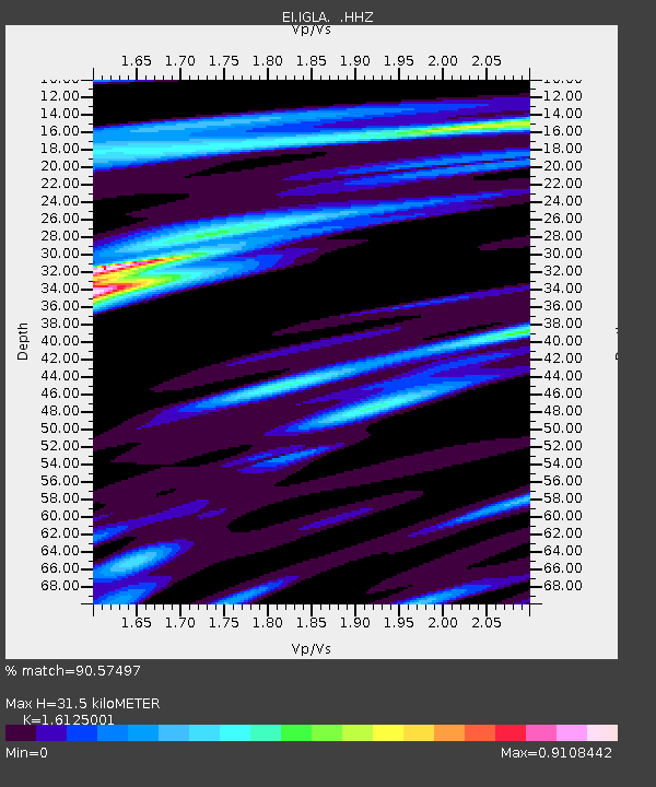
| Estimated Moho Depth: |
31.5 km |
| Estimated Crust Vp/Vs: |
1.61 |
| Assumed Crust Vp: |
6.276 km/s |
| Estimated Crust Vs: |
3.892 km/s |
| Estimated Crust Poisson's Ratio: |
0.19 |
|
| Radial Match: |
90.57497 % |
| Radial Bump: |
257 |
| Transverse Match: |
57.786377 % |
| Transverse Bump: |
400 |
| SOD ConfigId: |
512894 |
| Insert Time: |
2013-09-13 07:20:17.324 +0000 |
| GWidth: |
2.5 |
| Max Bumps: |
400 |
| Tol: |
0.001 |
|

Signal To Noise
| Channel | StoN | STA | LTA |
| EI:IGLA: :HHZ:20130416T10:53:27.44001Z | 2.2153838 | 5.652642E-6 | 2.5515405E-6 |
| EI:IGLA: :HHN:20130416T10:53:27.44001Z | 0.927968 | 1.8015999E-6 | 1.941446E-6 |
| EI:IGLA: :HHE:20130416T10:53:27.44001Z | 1.7302345 | 2.722898E-6 | 1.5737162E-6 |
| Arrivals |
| Ps | 3.2 SECOND |
| PpPs | 12 SECOND |
| PsPs/PpSs | 16 SECOND |


