You are here: Home > Network List > G - GEOSCOPE Stations List
> Station INU Inuyama, Japan > Earthquake Result Viewer
INU Inuyama, Japan - Earthquake Result Viewer
| Earthquake location: |
Southern Iran |
| Earthquake latitude/longitude: |
28.0/62.0 |
| Earthquake time(UTC): |
2013/04/16 (106) 10:44:20 GMT |
| Earthquake Depth: |
80 km |
| Earthquake Magnitude: |
7.7 MW, 7.0 MB, 7.7 MW |
| Earthquake Catalog/Contributor: |
NEIC PDE/NEIC PDE-W |
|
| Network: |
G GEOSCOPE |
| Station: |
INU Inuyama, Japan |
| Lat/Lon: |
35.35 N/137.03 E |
| Elevation: |
132 m |
|
| Distance: |
62.9 deg |
| Az: |
62.537 deg |
| Baz: |
286.359 deg |
| Ray Param: |
0.059735302 |
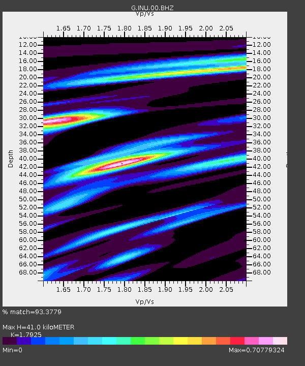
| Estimated Moho Depth: |
41.0 km |
| Estimated Crust Vp/Vs: |
1.79 |
| Assumed Crust Vp: |
6.461 km/s |
| Estimated Crust Vs: |
3.605 km/s |
| Estimated Crust Poisson's Ratio: |
0.27 |
|
| Radial Match: |
93.3779 % |
| Radial Bump: |
400 |
| Transverse Match: |
81.56285 % |
| Transverse Bump: |
400 |
| SOD ConfigId: |
512894 |
| Insert Time: |
2013-09-13 07:20:28.266 +0000 |
| GWidth: |
2.5 |
| Max Bumps: |
400 |
| Tol: |
0.001 |
|

Signal To Noise
| Channel | StoN | STA | LTA |
| G:INU:00:BHZ:20130416T10:54:07.060981Z | 17.107216 | 1.1039772E-5 | 6.4532844E-7 |
| G:INU:00:BHN:20130416T10:54:07.060981Z | 10.708414 | 2.7584754E-6 | 2.5759888E-7 |
| G:INU:00:BHE:20130416T10:54:07.060981Z | 12.356145 | 4.434982E-6 | 3.5892927E-7 |
| Arrivals |
| Ps | 5.3 SECOND |
| PpPs | 17 SECOND |
| PsPs/PpSs | 22 SECOND |


