You are here: Home > Network List > US - United States National Seismic Network Stations List
> Station MNTX Cornudas Mountains, Texas, USA > Earthquake Result Viewer
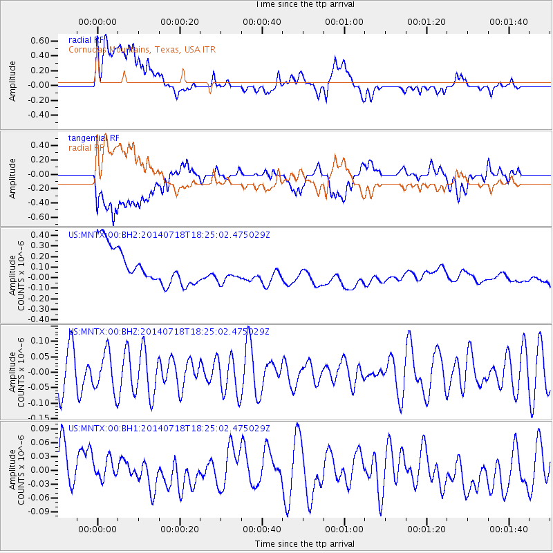
MNTX Cornudas Mountains, Texas, USA - Earthquake Result Viewer
*The percent match for this event was below the threshold and hence no stack was calculated.
| Earthquake location: |
Kuril Islands |
| Earthquake latitude/longitude: |
46.6/152.6 |
| Earthquake time(UTC): |
2014/07/18 (199) 18:13:49 GMT |
| Earthquake Depth: |
0.0 km |
| Earthquake Magnitude: |
4.7 mb, 3.8 ML, 3.6 mbtmp, 3.4 mb1mx, 3.7 mb1, 3.6 mb |
| Earthquake Catalog/Contributor: |
ISC/ISC |
|
| Network: |
US United States National Seismic Network |
| Station: |
MNTX Cornudas Mountains, Texas, USA |
| Lat/Lon: |
31.70 N/105.38 W |
| Elevation: |
404 m |
|
| Distance: |
75.1 deg |
| Az: |
59.595 deg |
| Baz: |
315.788 deg |
| Ray Param: |
$rayparam |
*The percent match for this event was below the threshold and hence was not used in the summary stack. |
|
| Radial Match: |
33.441208 % |
| Radial Bump: |
400 |
| Transverse Match: |
30.24508 % |
| Transverse Bump: |
400 |
| SOD ConfigId: |
3390531 |
| Insert Time: |
2019-04-12 22:39:03.107 +0000 |
| GWidth: |
2.5 |
| Max Bumps: |
400 |
| Tol: |
0.001 |
|
Signal To Noise
| Channel | StoN | STA | LTA |
| US:MNTX:00:BHZ:20140718T18:25:02.475029Z | 1.2055843 | 6.608999E-8 | 5.4819882E-8 |
| US:MNTX:00:BH1:20140718T18:25:02.475029Z | 0.53017044 | 3.751476E-8 | 7.075981E-8 |
| US:MNTX:00:BH2:20140718T18:25:02.475029Z | 0.6273742 | 1.04767835E-7 | 1.6699418E-7 |
| Arrivals |
| Ps | |
| PpPs | |
| PsPs/PpSs | |


